Monday, April 12, 2021

New Drone Rules Take Effect Today

WASHINGTON –Final rules take effect today for remotely identifying drones and allowing operators of small drones to fly over people and at night under certain conditions.

“Today’s rules are an important first step in safely and securely managing the growing use of drones in our airspace, though more work remains on the journey to full integration of Unmanned Aircraft Systems (UAS),” said U.S. Secretary of Transportation Pete Buttigieg. “The Department looks forward to working with stakeholders to ensure that our UAS policies keep pace with innovation, ensure the safety and security of our communities, and foster the economic competitiveness of our country.”

“Drones can provide virtually limitless benefits, and these new rules will ensure these important operations can grow safely and securely,” said FAA Administrator Steve Dickson. “The FAA will continue to work closely with other Department of Transportation offices and stakeholders from across the drone community to take meaningful steps to integrate emerging technologies that safely support increased opportunities for more complex drone use.”

The Remote Identification (Remote ID) rule provides for identifying drones in flight and the location of their control stations, reducing the risk of them interfering with other aircraft or posing a risk to people and property on the ground. The rule provides crucial information to our national security and law enforcement partners and other agencies charged with ensuring public safety. It applies to all drones that require FAA registration.

The Operations Over People rule applies to pilots who fly under Part 107 of the Federal Aviation Regulations. Under this rule, the ability to fly over people and over moving vehicles varies depending on the level of risk a small drone poses to people on the ground. Additionally, this rule allows operations at night under certain conditions provided pilots complete certain training or pass knowledge tests.

The public can review both the Remote ID (PDF) and Operations Over People Rule (PDF) in the Federal Register.

Monday, December 28, 2020

Press Release – U.S. Department of Transportation Issues Two Much-Anticipated Drone Rules to Advance Safety and Innovation in the United States


WASHINGTON December 28, 2020— The U.S. Department of Transportation’s Federal Aviation Administration (FAA) today announced final rules for Unmanned Aircraft (UA), commonly known as drones. The new rules will require Remote Identification (Remote ID) of drones and allow operators of small drones to fly over people and at night under certain conditions. These rules come at a time when drones represent the fastest-growing segment in the entire transportation sector – with currently over 1.7 million drone registrations and 203,000 FAA-certificated remote pilots.

Remote ID will help mitigate risks associated with expanded drone operations, such as flights over people and at night, and both rules support technological and operational innovation and advancements.

“These final rules carefully address safety, security and privacy concerns while advancing opportunities for innovation and utilization of drone technology,” said U.S. Secretary of Transportation Elaine L. Chao.

Remote ID (PDF) is a major step toward the full integration of drones into the national airspace system. Remote ID provides identification of drones in flight as well as the location of their control stations, providing crucial information to our national security agencies and law enforcement partners, and other officials charged with ensuring public safety. Airspace awareness reduces the risk of drone interference with other aircraft and people and property on the ground.

Equipping drones with Remote ID technology builds on previous steps taken by the FAA and the drone industry to integrate operations safely into the national airspace system. Part 107 of the federal aviation regulations currently prohibits covered drone operations over people and at night unless the operator obtains a waiver from the FAA. The new FAA regulations jointly provide increased flexibility to conduct certain small UAS without obtaining waiver.

“The new rules make way for the further integration of drones into our airspace by addressing safety and security concerns,” said FAA Administrator Steve Dickson. “They get us closer to the day when we will more routinely see drone operations such as the delivery of packages.”

The Remote ID rule (PDF) applies to all operators of drones that require FAA registration. There are three ways to comply with the operational requirements:

1. Operate a standard Remote ID drone that broadcasts identification and location information of the drone and control station;

2. Operate a drone with a Remote ID broadcast module (may be a separate device attached to the drone), which broadcasts identification, location, and take-off information; or

3. Operate a drone without Remote ID but at specific FAA-recognized identification areas.

The Operations Over People and at Night rule (PDF) applies to Part 107 operators. The ability to fly over people and moving vehicles varies depending on the level of risk a small drone operation presents to people on the ground. Operations are permitted based on four categories, which can be found in the executive summary (PDF) accompanying the rule. Additionally, this rule allows for operations at night under certain conditions.

The final rule requires that small drone operators have their remote pilot certificate and identification in their physical possession when operating, ready to present to authorities if needed. This rule also expands the class of authorities who may request these forms from a remote pilot. The final rule replaces the requirement to complete a recurrent test every 24 calendar months with the requirement to complete updated recurrent training that includes operating at night in identified subject areas. 

Both rules will become effective 60 days after publication in the Federal Register. The Remote ID rule includes two compliance dates. Drone manufacturers will have 18 months to begin producing drones with Remote ID, with operators having an additional year to start using drones with Remote ID.

Wednesday, September 30, 2020

Freefly and Auterion announce the release of Astro

 Los Angeles, California – 30 September – Freefly Systems, leading drone manufacturers and Auterion, the largest open source drone software platform announced the releases of the Astro Enterprise Drone Solution. In partnering, the two companies have combined their respective expertise in hardware and software to build and release the Astro – the best multi use enterprise drone for utility, telco, and infrastructure companies, as well as drone service providers and first responders.

The Astro will provide enterprise and government customers a highly capable workhorse drone for mapping, inspection and first responders to capture media, automate processes, and streamline data flows through Auterion’s enterprise-ready software platform.

With a 2 lb payload, the Astro can achieve a 30 minute flight time, supports over nine payload options including the industry leading 60 megapixel Sony α7R IV, folds into a backpack, is weather sealed, and cloud connected. The Astro is engineered and built by Freefly around the Auterion Skynode reference design and is powered by Auterion Enterprise PX4 software on board and by Auterion Mission Control on the ground station. The platform provides customers’ with fleet management, 4G LTE connectivity for online workflows, predictive maintenance, geotagging, and the Auterion SDK for enterprise developers. 

With 10 years of experience in developing drone hardware systems and with thousands of tested flight hours, Freefly has a reputation of building the industry’s toughest drones as well as a track record of offering the best customer support in the industry.

The team behind Auterion has been developing software for drones for over 10 years, and provides an ecosystem of payloads and radio links, expertise in connected workflows for enterprises, while driving open standards to support innovation and scalability within the industry.

The partnership between Freefly and Auterion delivers a drone system that is greater than the sum of its parts. Freefly relentlessly pursues hardware excellence that exceeds their customers expectations, while Auterion enables the user to tap the full power of the Astro by creating a cohesive software ecosystem and user experience. 

Tabb Firchau, CEO of Freefly says, “Partnering with Auterion to bring the Astro to market allowed us to aim much higher than we could have on our own. As a small self-funded startup of 35 people we have huge ambitions and often end up having to cut scope from the end product.  Working with Auterion allowed us to deliver even more than we originally planned. The open architecture and collaborative nature at Auterion enabled several key pivots during the product development process, ultimately landing on a product that is more flexible, efficient, and ultra adaptable. We can’t wait to see what users will think!”

“Sony is excited about Auterion-Freefly team’s usage of our new SDK to integrate the Alpha 7R IV full-frame camera into their new enterprise drone system,” said Neal Manowitz, Deputy President of Imaging Product and Solutions Americas for Sony Electronics. “We will continue to evolve our software to meet the growing demands of commercial clients, ultimately allowing them to capture, measure and create in ways never before possible.” 

Lorenz Meier, Auterion co-founder and CEO said, “The release of Astro is the culmination of more than a decade of work to make open source the default in the commercial drone industry. Auterion Enterprise PX4 is giving businesses a trusted, known base and better integrations than any of the proprietary alternatives.”

The Astro is available for pre-order today with first units shipping in Q4 2020. 

For more information about the Astro visit www.freeflysystems.com/astro. For more information about the Auterion software platform visit www.auterion.com/enterprise.


Friday, July 24, 2020

Drones and Image Analysis Help Locate Gravesites


Loc8 is pleased to announce that it will be collaborating with Texas State University and the University of Missouri on a $280,000 grant to utilize drones to locate human remains and detect clandestine graves. This grant, which was awarded by the National Institute of Justice (NIJ), continues the groundbreaking research conducted in 2015 by Gene Robinson, president of GRC Consulting, and the Texas State Anthropology Department.

drone, uas, uav, grave, human, remains, nij,

Dr. Daniel Wescott of the Forensic Anthropology Center at Texas State states that this two-year project is challenged with documenting the ways drone technology and their payloads (various multispectral cameras) can be used and how it differs with traditional ground-based studies. Loc8 is collaborating with the project to bring its patent-pending image analysis algorithms into the field of aerial forensic science.

Pilot for the NIJ project Gene Robinson stated, “The ability of Loc8 to scan down to the individual pixel level in each image is going to change the way remote sensing is used in search and rescue (SAR) missions and crime scene investigations. The Loc8 software has only been available since 2019 and we have already realized successes in the field. We are just now scratching the surface in the different ways Loc8’s image analysis algorithms can be used.” The NIJ project is slated to handle a wide array of remote sensors from standard RGB, to near infrared (NIR), to thermal (FLIR) and multi-spectral imagery to detect subtle changes in the environment resulting from human remains on or under the ground from the vantage point of a deployed drone.

The NIJ Grant project data collection flights began in late January 2020. Over the next two-years, the flights are scheduled to continue on a near daily or weekly basis depending upon the stage of the study. The research is being conducted in the Texas State University’s 26-acre open-air forensic laboratory. Under the NIJ project, eight to ten science pledged body donation volunteers (cadavers) will be studied under various scenarios designed to mimic ground conditions of undiscovered clandestine sites. The University of Missouri is tasked with the image/data analytics and will act as the repository for all the data collected.

Robinson added, “The Texas State Forensic Anthropology Research Facility replicates conditions and environments of some of the tough cases we have encountered in the past 15 years. We can really bring the current technology to bear in a scientific way that will be a tremendous benefit to both law enforcement and the search and rescue community.”

The research has already begun at the Texas Hill Country facility and will simulate different environments and seasonal effects on the forensic investigative process. The project will identify best practices for drone utilization, determine the most effective sensors, and explore the advantages of using an image analysis software like Loc8 to enhance the effectiveness and thoroughness of the search and rescue or recovery investigative process.

As part of the NIJ Project, Gene Robinson will be cataloging the changes in the color palettes of the volunteer subject’s skin, soft tissue, and skeletal remains during the natural decomposition process. These color palettes will then made available as sample data sets for Loc8 subscribers to use during their search and rescue/recovery missions. The Human Remains color palette dataset is one of many datasets Loc8 is developing to assist subscribers.

Loc8 (www.loc8.life) is a patent-pending image scanning technology that analyzes the individual pixels in a digital image (still or video) by searching for colors that match a userdefined color palette. Once the defined pixel color(s) are detected in the scanned images, Loc8 reports the latitude, longitude, and the altitude of the geographical location of the detected item(s).

Loc8 was originally developed to scan digital images (still or video) quickly and thoroughly collected during search and rescue/recovery (SAR) missions. However, since its release, the Loc8 algorithm has been tested as a tool in crime scene investigation, accident reconstruction, debris field mapping, precision agricultural management, wildlife population management, and utility infrastructure inspections, to name a few of the many potential applications.


Monday, June 29, 2020

New DJI Drone Rescue Map Tracks Drone-Assisted Rescues Worldwide

drone, UAS, UAV, SAR, search, rescue, public safety,


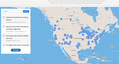
DJI, a leader in civilian drones and aerial imaging technology, today launched an online reference to track events around the world when a drone helped rescue someone from peril. The Drone Rescue Map, available online at https://enterprise.dji.com/drone-rescue-map, shows how more than 400 people around the world have been helped by drones in more than 200 emergencies, and will be continually updated as new rescues occur.

The DJI Drone Rescue Map has been compiled from news stories and social media posts from authoritative sources such as police departments, fire departments and volunteer rescue squads. Each entry on the map includes the location and date of the incident, a brief description, a link to the original story or post, and an easy way to share those incidents online. To make the map as definitive as possible, DJI encourages public safety agencies to share additional drone rescues so they can be included.

“The DJI Drone Rescue Map is now the best global reference for how effective drones are in emergencies, and allows the world to see the tremendous impact drones have had in finding lost people, shortening searches, reducing risks to rescuers and saving lives,” said Romeo Durscher, DJI Senior Director of Public Safety Integration. “Public safety workers already know how drones are revolutionizing their work, and now the rest of the world can see their amazing stories in one place. The DJI Drone Rescue Map honors the incredible rescues they’ve made, and will allow everyone to see how drones help save people in the future.”

The DJI Drone Rescue Map includes instances of drones finding people lost in forests, fields and mountains, often in darkness using thermal imaging cameras; dropping life preservers to people struggling in water; locating boaters stranded on remote waterways; and helping rescue people who were at risk of harming themselves. The map does not include incidents when a drone is simply used as part of a larger search process; instead, a drone must have directly located, assisted and/or rescued a person in peril.

Many of these incidents illustrate how drones can find missing people more quickly than a traditional ground-based search, allowing victims to be brought to safety faster, more easily, and with less risk and burden for their rescuers. In some of the incidents on the DJI Drone Rescue Map, the drone helped accelerate a rescue and allow first responders to operate more efficiently. In other incidents, the drone clearly made the difference between life and death.

“I know how important drones are for people in distress, because a drone saved my life,” said Jason Mabee, a Maryland man who was injured and near death last year in a local park when he was found by a volunteer drone pilot. “My family and I are eternally grateful that a total stranger was able to use his drone to find me. It’s comforting to know that drones are helping so many other people around the world too, and I hope the DJI Drone Rescue Map demonstrates just why drones are so important in emergencies.”

“Drones have changed the game for finding and saving people lost in difficult conditions, and twice last year drones made the difference for us in finding and saving stranded hikers in dangerous terrain at night,” said Kyle Nordfors, Drone Team Coordinator for Weber County Search and Rescue in Utah. “Drones helped make these rescues possible while reducing risk and strain on our volunteer rescue force. We’re excited to see our successful efforts represented on the DJI Drone Rescue Map, and we hope it shows people all over the world how important drones are for saving lives and protecting the rescuers.”

PC Tom Shainberg, Senior Drone Pilot of the Alliance Drone Team for the Devon & Cornwall and Dorset police forces in England, said: “The Alliance Drone Team is proud to be a leader in adapting drone technology for police incidents, and we’re glad to see our successful drone rescues – such as finding a vulnerable man huddled near the edge of a cliff – being shared wider, along with similar accomplishments from other public safety agencies from around the world via the Drone Rescue Map.”

The map includes rescues recorded in 27 countries across five continents, and shows how drone technology has moved from an experimental concept to standard public safety equipment. The first drone rescue was recorded in Canada in 2013, the next one was more than a year later, and early examples of drone rescues were as likely to be performed by helpful bystanders as by professionals. Today, drone rescues are reported about once a week on average, and public safety agencies routinely share those success stories on social media.

“Hundreds of examples now make clear that making drones widely accessible, with low barriers to entry and subject to a progressive set of operational regulations, leads inevitably to saving more lives around the world,” said Brendan Schulman, DJI Vice President of Policy & Legal Affairs. “The DJI Drone Rescue Map is a powerful resource for policymakers to understand the impact drones have on protecting vulnerable people in their own communities, and the detrimental consequences of policies that would restrict or discourage the use of drones, or increase the cost of using them. Regions with less favorable operating rules for drones appear to have substantially fewer reports of drone rescues.”

DJI has previously released two detailed reports on how drones have been used to rescue people from peril around the world. The first, in 2017, counted 59 people rescued by drones, and the second saw the global total rise to 124 by 2018. DJI monitors global news coverage, drone-related social media, and other sources to find new examples of drone rescues, but understands that many similar incidents may not yet be recorded on the map. Anyone who knows of a drone-involved rescue not included on the DJI Drone Rescue Map can submit it through a form at the bottom of the map page. These submissions will be reviewed for publication on the map, so DJI asks anyone submitting information about a rescue to respect the privacy rights and expectations of the persons involved, and to not share any confidential or sensitive information about agency operations.

Wednesday, June 24, 2020

Canoers rescued from Bridgewater’s Town River with the help of a drone


The Enterprise June 22, 2020
BRIDGEWATER — Two men whose canoe was damaged on the Town River were rescued with the help of drone thermal imaging.

drone, uas, uav, search, rescue, sar, river, swiftwater, water

“Deploying the drone from the deck of the fire boat and using thermal imaging gave responders the visibility they needed to locate the individuals,” Bridgewater Police Chief Christopher Delmonte said in a statement.

The father of one of the men called West Bridgewater police around 8:30 p.m. Saturday and reported that the canoe his son and friend were in was damaged and taking on water.

Bridgewater police and fire units went to the Lake Nippenicket boat ramp to launch their rescue boat. An officer and firefighters went to the northern part of the lake to enter the Town River.

First responders were able to talk to the canoers, but were not immediately able to identify their exact location, according to police. Officer Chris Rondeau launched a drone from the boat to search the area with thermal imaging.

From footage of the rescue, the 22-year-old men were seen waving at the drone when it found their location, which was about 200 feet away from the boat.

The men were rescued from the chest deep part of the river and brought back to shore, where they were evaluated and reunited with families.

Delmonte said the weather conditions were favorable for the rescue and the canoers were not injured.

“This rescue effort is a great example of the Bridgewater police and fire departments working together,” Fire Chief Thomas Levy said in a statement. “I commend the quick action of the individuals involved with this water rescue.”

Tuesday, June 9, 2020

Drone Leads Rescuers to Overdue Backpackers in Aspen

The Aspen June 5, 2020
Two overdue backpackers were located Wednesday with the help of a search and rescue drone after deep snow unexpectedly delayed the pair’s 27-mile long journey through the Maroon Bells Wilderness Area.


According to Mountain Rescue Aspen, the two males in their 20s set out for a three-backpacking trip on Sunday. The backpackers intended to hike the Fravert Basin, also known as the Four Pass Loop. When the pair did not return on Tuesday as expected one of their family members reported them overdue. 

A massive search was launched for the overdue backpackers, including the use of a drone, helicopter, fixed-wing aircraft, and  10 search and rescue personnel.

A drone flying at about 500 feet in altitude spotted the overdue backpackers at about 5:20 p.m. near Crater Lake. They were found tired, but uninjured.  Despite the snowy conditions slowing down their progress, rescuers say both backpackers were “well equipped” to spend an extra night in the wilderness.