Showing posts with label fire. Show all posts

Wednesday, April 24, 2024

Aloft Introduces Automated SGI Waivers in Aloft Air Control, Streamlining Access to Restricted Airspaces

 Aloft Technologies, Inc. (Aloft), a leader in advanced drone software solutions, is thrilled to announce the integration of Automated Special Government Interest (SGI) Waivers into its Aloft Air Control platform. This new feature is set to revolutionize how drone operators access restricted airspaces, significantly enhancing operational efficiency and compliance with federal regulations.


Automated SGI waivers are available today for all Aloft Air Control enterprise customers.

The Automated SGI Waivers functionality simplifies the complex and time-consuming process of obtaining necessary permissions for drone operations in sensitive or restricted areas. This development reflects Aloft’s ongoing commitment to innovation and its dedication to supporting the operational needs of its clients across various industries, including public safety, emergency response, and infrastructure inspection.

Jon Hegranes, CEO and Founder of Aloft, commented on the new feature, saying, “We understand the critical nature of time-sensitive operations, especially in scenarios that involve public safety and emergency responses. Integrating Automated SGI Waivers into Aloft Air Control not only streamlines the approval process but ensures that our clients can deploy their drones quickly and legally, even in the most restricted airspaces. This capability is about empowering our users to focus more on their mission-critical tasks and less on bureaucratic hurdles.”

The Automated SGI Waivers are designed to interact seamlessly with existing features within the Aloft Air Control ecosystem, providing a comprehensive solution for airspace management that includes pre-flight planning, real-time traffic alerts, and post-operation analysis. This integration ensures a smooth, intuitive user experience and upholds the highest safety and compliance standards.

Key benefits of the Automated SGI Waivers include:

-Reduced Approval Times: Drastically cuts down the waiting period for gaining airspace access, facilitating rapid response and operational readiness.

-Enhanced Compliance: Ensures that all drone flights are compliant with current FAA regulations, minimizing legal risks and enhancing public safety.

-Streamlined Operations: Integrates with the overall flight management system to provide a unified workflow from planning to execution.

This innovative feature is expected to set a new benchmark for operational efficiency in drone technology, reflecting Aloft’s role as a pioneer in the industry. With one click, users can transform an existing mission in Aloft into an auto-generated SGI form ready to email to the FAA’s SOSC Office.

For more information about Automated SGI Waivers and Aloft Air Control, please email sales@aloft.ai or contact your Aloft customer success representative.

About Aloft Technologies, Inc.:
Aloft Technologies, Inc. specializes in developing advanced drone software solutions, empowering businesses and government entities to manage their drone operations with enhanced efficiency, safety, and compliance. Based in Syracuse, NY, Aloft continues to lead the way in airspace and fleet management technology. Aloft’s UTM network and Air Control platform is utilized by hundreds of government and public safety agencies.

Friday, July 28, 2023

Drones for Public Safety Operations Course September 15-17, 2023

 
Rowan Cabarrus Community College (RCCC) in conjunction with Blue Ride Mountain Drones and EMMU Aerial is proud to announce our Drones for Public Safety Operations Course September 15-17, 2023 at:

RCCC North Campus 1333 Jake Alexander Blvd. Salisbury North Carolina      

Drones allow public safety organizations to augment their ground public safety teams and move beyond their vehicles in order to execute aerial search and rescue missions, provide improved situational awareness, assist with exposure reduction and provide mapping capabilities more efficiently. This is a three-day public safety drone training course with 1 day classroom and 2 days situational field / flight training. Students will gain knowledge and practical experience in pre-planning, incident management, mission planning, scene management, drone platforms and payloads, software, safe drone operations, drone search and rescue missions, mapping, thermal imaging, and night operations. Learn to successfully fly SAR missions and other supporting missions. The course will enable the students to identify clearly their own limitations as well as those of the equipment, so that they will be able to utilize drones safely and effectively.    

 Prerequisites:

  • FAA Part 107 or public agency COA certification
  • Basic flight experience – 5 hours of flying
  • Completion of FEMA IS-100, 200 and 700 
  • Agency approval to attend course. 
  • One drone for every three students

Registration is available online; RCCC Online Registration

Monday, July 10, 2023

4 rescued from Yellowstone River near Billings

Emergency response teams in Billings joined forces in a highly effective multi-agency water rescue operation, resulting in the safe recovery of four individuals on Sunday night. This collaborative effort demonstrated the exceptional coordination and utilization of advanced technology to respond to water emergencies.


On July 9, 2023, emergency services responded to a distress call reporting a water emergency involving multiple individuals in the Yellowstone River near South West Billings at 8:59 p.m. The Billings Fire Department, the Yellowstone County Sheriff's Office, AMR, and additional fire units swiftly arrived at the scene, ready to provide assistance.

The incident commander immediately initiated a well-coordinated response, with each agency utilizing their specialized resources and expertise. The Billings Fire Department's drone team played a critical role in the operation by deploying an unmanned aerial vehicle equipped with an infrared (IR) camera. The IR technology proved invaluable in locating the stranded victims, even in challenging conditions of darkness.

In the first phase of the operation, the swift water rescue team from the Billings Fire Department successfully executed the rescue of an individual stranded on a tree in the middle of the river around 9:30 p.m. Simultaneously, responders focused their efforts on the rescue of three additional individuals who were stranded on an island in the river. These rescues spanned from 10 p.m. to 11:30 p.m. The Sheriff's Office Rescue Boat, operated by the Sheriff's Office and supported by swift water technicians from the Billings Fire Department, navigated the challenging waters and facilitated the safe recovery of the individuals.

This incident highlights the inherent risks associated with water activities, particularly in rivers, and serves as a reminder for all individuals engaging in such activities to prioritize their safety. The Billings Fire Department urges everyone to wear a properly fitting and U.S. Coast Guard-approved life jacket, as it significantly increases the chances of survival during water emergencies. Additionally, individuals should inform a trusted person about their plans, including the intended location, expected return time, and any changes to the itinerary, to facilitate a swift response in case of an emergency.

The individual stranded in a tree had an inexpensive raft that flipped and she then became tangled in a tree.

The second set of victims were looking for their friend and got stranded on the island.

The successful outcome of this water rescue operation was a testament to the joint efforts and seamless collaboration between the Billings Fire Department, the Yellowstone County Sheriff's Office, AMR, and other supporting agencies. Their commitment to public safety, coupled with the utilization of advanced technology, contributed to the successful recovery of all four individuals involved.

Victoria Hill, the public information officer for the City of Billings:


Friday, May 5, 2023

Drones Credited With Life-Saving Rescues in Northern Ontario


Scott Grant, the chief of the Moosonee Volunteer Fire Department, says a $46,000 investment has already saved two lives in the last week alone.

DJI 30 Matrice thermal drone, purchased by the department just over a year ago, has already flown to more than a dozen incidents in the region, including finding a man lost in the bush on Wednesday night.  

And on Sunday night volunteer firefighters located a woman  – already showing signs of hypothermia – trapped on an ice chunk in the Moose River. 

The dramatic rescue began with a call to 9-1-1 and local firefighters about 9:30 p.m.

"There's a woman, she's out there screaming on the ice," Grant said. "Obviously she seems lost and she's quite far out there." 

A couple of weeks earlier, the ice had begun its imminent, annual breakup, and several patches of open water were visible.

Grant said he contacted his drone team, who met him by the shore of the river. The sun had set, and crew's flashlights became nearly useless in trying to find the woman on the river. Grant spoke to the lady using a bullhorn, encouraging her to remain calm while teams planned a route across the treacherous ice.

"I'm sure it's quite terrifying being out there, especially when it's getting dark out," Grant said. "We could barely make her out at that point. And we can't send crews out on an ice surface without knowing the location of where they're going."

Out of fear or panic, the lady also began wandering across the ice floe, Grant said, making it difficult to pin her exact location down. It also put her in danger of plunging into the icy water.

While cold-water rescue teams and firefighters prepared on shore, Grant deployed the drone team. 

"We ended up locating her approximately 600 meters from shore," Grant said, adding that the drone's thermal camera was able to locate her in the dark, "locking on" her location.

"Once we had her location, we ordered the drone to hover directly over top of the individual. So even though we could not see her, we knew exactly where she was."

Rescue teams then were able to navigate to the point, set the woman in an inflatable vessel, and pull her back to shore.

The entire operation, he said, took about 40-45 minutes, in a situation where every minute counts.

Once on shore, Grant said, the woman was taken to a local health clinic with signs of hypothermia. She has since been "feeling better," Grant said, and is resting at home.

The Drone in Action

Grant says the drone represents a "fantastic opportunity" for search and rescue operations.

"Even if we know where the individual is, let's say, on the ice," Grant said. "We can use that drone and put it up in the air and get a good 360 degree view of what we're going into."

"It definitely gives us a lot more confidence to be able to know exactly what we're getting into or give us a better idea of what we're entering," Grant said. "It gives us a really good ability to plan further a few steps ahead of time."

The drone allows for a full aerial survey of the area, saving hours of work for rescue teams, who typically will search an area by arranging themselves and covering ground in a grid-pattern.

"It really also helps ensure that no area gets missed," he said. "No area gets passed over."

The Moosonee Volunteer Fire Department joins a list of emergency services using drone technology to save lives, or in some cases, investigate crimes.

In 2021, SafeSight Exploration announced they had developed a new drone specifically adapted to operate in underground mine rescue situations, where debris and smoke can obstruct rescuers.

Ted Hanley, vice-president of Ontario Mine Rescue, said a rescue scenario underground presents a more challenging environment in which to operate a drone, because there are many unknowns, and smoke, fire and debris can impede their sensors.

"The UAV [drone] or any robotic technology that's unmanned, being able to inspect an area during an emergency is potentially bringing us back that missing percentage of information that can allow us to make a safe decision on whether to send or not send rescuers into an area," Henley said.

Shared from CBC.CA

Wednesday, June 29, 2022

Phoenix Fire Department announces use of drones to fight fires

Earlier this month, the Phoenix Fire Department began using drones to help crews on the ground better do their jobs. The department has three drones and FAA certifications for eight drone pilots.

Phoenix Fire Cpt. Kenny Overton said the drones flying overhead give firefighters already on the scene a safe way to get more information.

“This is going to enable us to deliver better service to the citizens of Phoenix and also better protect our firefighters in active incidents," Overton said.

The program has been implemented since June 6, aiding with active structure fires. The drones send a live video feed to the command team’s monitors.

Overton, who is FAA certified himself, says the aerial view gives firefighters more opportunities to make informed decisions in intense situations, like spotting possible hazards or helping with search and rescue operations.

Overton noted that the use of drones is supplementary to firefighters' initial response. 


Friday, June 24, 2022

First Responders Reflect on Lessons Learned from Surfside

First responders and specialized units rushed to the Champlain Towers South within hours after the building collapsed on June 24, 2021. 

“To get two full-sized urban search and rescue teams there within the first 24 hours is unheard of,” said Dave Downey, the former Miami-Dade Fire Rescue Chief, who now works with the Florida State Fire Marshal.

Downey, who was in the command post at Surfside, said being able to communicate effectively with all the different response teams was key as well as getting rescuers the tools they needed.  

“...As a tool broke, we just moved it off and moved a new tool in and they repaired the tool that was broken. There was no interruption. We had never done that.”

In addition, they learned that heavy cranes need to arrive almost as quickly as the search teams. 

“You can’t work a collapse rescue without cranes, without excavators and making sure that you know where these are and how to get them into your area,” Downey said.  

The rescue teams also used drones. 

“We were able to fly a drone into the underground parking garage that was completely pancaked and to be able to get around vehicles and do as close to a search as we could for any victims,” Downey said.  

The team members who worked the site told NBC 6 that the technology the Israelis brought to the scene made a difference.  

 “Almost a reenactment of the building, how it fell, where people could possibly be in the rubble,” said Miami-Dade Fire Rescue Capt. Erik Sada. “It was kind of a new way of searching and finding people we have not had in the past.”

Downey added, “They were able to map that out and help us line up stairwells, rooms, apartments, and they were really spot on.” 

When asked what’s the ultimate takeaway, Downey said, “Through experience, through training you always get stronger … This type of thing, as tragic as they are, they make us stronger for the next time.”


Wednesday, June 15, 2022

How Cal Fire Uses Drones To Fight Wildfires

 Cal fire is using new drone technology to fight wildfires. Giving them a bigger picture of wildfires so they know how to best put them out. 

It's already a busy season for firefighters with wildfires sparking up more often. The drones Cal Fire uses give firefighters more resources.

"They're able to give us any type of heat source, or if there's an evacuation being put in place, or we have trapped people, they can identify those people and actually know where they're at on the incident," said Captain Richard Cordova with Cal Fire Riverside.  Read More.

Friday, June 4, 2021

NASA Takes on Wildfires with Flight Demonstration

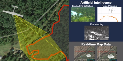
NASA Takes on Wildfires with Flight Demonstration @UASMagazine: Helping make the battle against wildfires faster, safer, and more targeted, a NASA project recently tested its tools in a realistic wildland firefighting exercise.


Saturday, May 23, 2020

Drone and Ropes Help Rescue Drivers Trapped in River

Well done firefighters, It’s good to see positive use of drone.


May 18, 2020
Firefighters use a drone and ropes to rescue drivers trapped in river due to sudden water rise in Zhangjiajie, China.

Friday, May 1, 2020

Drones: Incident Response & Decision-Making

A good read, Where Wayne Baker emphasizes that the use of drones for emergency incidents must be balanced with proven human methods.
drone, uas, uav, public safety, fire,
Standard aerial imagery from drones enhances scene size-up, and thermal aerial imagery helps to improve searches and to mitigate risks to firefighters. That said, the technology shouldn't replace ground-level strategies and tactics.
Firehouse.com  Wayne Baker May 1, 2020
Throughout my career as a firefighter/paramedic, I trained and prepared extensively to respond to a variety of incidents. Later, as a fire chief and an emergency management coordinator, I prepared to coordinate and facilitate incident response at a broader level. 

No matter the incident or my role, having enough actionable data and information to make the right incident action plan was a challenge. I sought tools, techniques and technology that would make my crews better informed for efficient and safe operations.

For me, drone technology and its associated tools and tactics became one of the most significant advances for this information-gathering on incident response.

Although the adoption of this technology by public safety has been rapid, many questions still surround the use of drone technology in incident response and decision-making, for example: What tactics and techniques exist for utilizing drones on incidents? What tools can be used in information-gathering? How do you analyze and act upon data? Of increasing importance, how do we better maintain aircraft? Answers to these questions will continue to evolve as the technology continues to improve. Read More

Wednesday, April 15, 2020

IBM, Microsoft, Aerovironment and Nvidia Pit AI Against Wildfires


AeroVironment has been working with Nvidia and Microsoft to deliver a prototype AI-enabled system that could help bring advanced wildfire management.

Aerovironment, wildfire, wildland, fire, drone, uas, uav

 In 2018, California experienced its worst wildfire season on record, with uncontrolled fires causing unprecedented death and devastation. 2019 saw another difficult season, with millions of residents experiencing precautionary power shutoffs. With much of the world self-quarantining and the 2020 fire season looming, Nvidia’s virtual GTC 2020 hosted a panel highlighting how AI practitioners are working with forest stewards to bring fire management into a new, data-enabled era.

Firewatch duty was traditionally served by fire lookouts on towers overlooking forests, but moving that role into the 21st century is easier said than done. In order to be truly useful to first responders in a wildfire, an AI model needs to be able to detect smoke – not fire – very, very quickly. After all, by the time a fire is large enough to be easily spotted, it’s typically less containable, and if the smoke is reported too late to act on it, the fire will have had substantial time to grow.  Read More


Sunday, April 12, 2020

Overcoming the Challenges of Starting a Public Safety Drone Program

Lynwood Fire Department Shows the Value of Drones for Small to Mid-Sized Agencies

DJI Enterprise April 4, 2020  
In the fall of 2017, in Peru, Illinois, an armed suspect has barricaded himself inside a suburban home after firing at police officers. The apparent suspect’s emotional instability, the fact that the suspect was former military with explosives experience and the threat he made of placing IEDs around the house are making the situation worse. Well over 150 public safety personnel surround the house. Fortunately for the tactical teams and emergency response crew, the suspect is willing to negotiate.

Calling for Help

As the day wore on, the incident commander knew that the coming night would only complicate the situation. He asked his team what options they had. Chief Ed Rogers, of the Utica Fire Department, immediately thought of the Lynwood Fire Department and their UAS operations program. Thermal imaging paired with a clear aerial view of the house would provide acute situational awareness in case the suspect made a run for it. 

After receiving the call, Keenan Newton, Lieutenant and UAS coordinator of the Lynwood FD, arrived on site before dusk. As he and his team began unloading their equipment, the suspect told the negotiator that his phone was low on battery. Negotiators knew they had to keep talking with the suspect to help ensure a peaceful outcome. It was a tense moment. Everyone anticipated the situation intensifying unless the suspect was provided a new phone. Something had to be done.

The first attempt to deliver a phone with a law enforcement robot failed. As it had a technical failure. The incident commander looked at Chief Rogers and asked if the phone could be delivered with a drone. “Of course we can, we’re firemen,” Chief Rogers responded.

Keenan got to work immediately. Utilizing a drop release system, a remote-controlled drop mechanism used for deliveries, on a DJI M600 Pro drone, he would attempt to swing the phone into the suspect’s bathroom window. Two Inspire 1 drones were flown nearby to help spot and guide the drop, as well as record the delivery. The cell phone was tied to a rope, and within minutes the drone was hovering over the house. Approaching carefully, Keenan successfully positioned the cell phone just outside of a window and swung it towards the bathroom window until the suspect grabbed it. 

public safety, drone, uas, uav, program,

Tuesday, March 24, 2020

Drones Aid Foresters

Two drones are on test runs in Florida to scope out firefighters on the ground and record prescribed burns from above.  Although drones aren’t yet utilized in Nassau County, the Florida Forest Service has two drones that are sent out as part of a testing phase elsewhere in the state,...

Two drones are on test runs in Florida to scope out firefighters on the ground and record prescribed burns from above.

drone, uas, uav, forestry, florida, wildfire, wildland, fire,

Although drones aren’t yet utilized in Nassau County, the Florida Forest Service has two drones that are sent out as part of a testing phase elsewhere in the state, including Hernando County and the Withlacoochee Forestry Center, according to FFS Wildfire Mitigation Specialist Robert Chase. The project began in 2019. 

“We believe the greatest potential for use of drones in the Florida Forest Service to be in the realm of forest management activities such as prescribed fire, monitoring timber sales and surveying forest landscapes for forest health issues,” Chase said. “We anticipate using a drone for helping with ignition on prescribed burns on our state forests. There are additional attachments that we could also utilize that would allow us to do some thermal imaging. This would be helpful in our mop-up phases to see where pockets of heat may remain in a wildfire area, allowing us to better concentrate our efforts. We hope to be able to utilize a drone locally in the future for those activities.”  Read More

Monday, March 23, 2020

Drones for Search and Rescue (SAR) – Another Tool in The Toolbox


“In order to realize the true value of a drone’s capabilities, Drone Pilots and SAR authorities from the Incident Commander (IC) on down need to gain experience by employing drones on actual SAR operations and in training.  Only then will you realize that drones provide another tool in the toolbox for the Incident Commanders that can and will prove invaluable”

Drones have quickly become the most widely used tool for many industries. From Police and Fire Departments to agriculture and energy operations, drones have become essential to boosting safety and productivity.

drone, uas, uav, search and rescue, sar,

A search and rescue drone used by emergency services, such as police officers, firefighters or volunteer rescue teams, is ideal for searching over vast areas for missing persons and crime victims in need of rescue and in any environment.  Search times can be significantly reduced while limiting potential risk to the party being rescued as well as rescuers. There are many options and benefits to using drones for search and rescue.

Thermal imaging or forward-looking infrared (FLIR) is a major benefit for search and rescue. Body heat naturally makes humans stand out from plant life, making them easy to spot very quickly.  Most thermal cameras also have the option to change temperature search range and the color palette for a wide variety of options to make sure you can see exactly what you’re looking for.

Almost all commercial drones come equipped with GPS, allowing the pilot to offer rescue teams the exact GPS coordinates of the subjects once they have been spotted. With the live view feature of any drone used for search and rescue, the pilot can also guide rescue crews to their location.

There is no point sending any aircraft into the air for SAR if the visuals can’t be relayed to the ground search team or incident command as is often the case for manned aviation.  Many drones have the capability to stream live video from the controller to a monitor for on-site viewing or to a broadcast terminal to send to a remote incident command center on a larger monitor for easier identification of subjects in real-time.

This allows pilots or incident command crews to guide rescue teams to the precise location of their subjects, and the aerial view also aids in guiding those crews around any obstacles or hazards that may be in their path.

Too find out more on how you can develop a drone program for your search and rescue organization, contact Dave Crago at cragod1@gmail.com


Do you have a story of drones coming to the rescue or assisting your agency? Please share in the comments.

Thursday, March 19, 2020

Public Benefits of Drone Technology

Drones have become a familiar aspect of our contemporary world. Over the past decade, they’ve graduated from expensive toys of the rich to affordable items that many of us have the opportunity to experience. They are used in photography and deliveries, and have even become the subject of their own racing events. But drones also have a vital part to play in the public sector. 
This isn’t necessarily limited to their military applications, either. Governments and public services — local and national — have begun to explore ways in which drone tech can make a real difference in our lives. Public leaders are embracing the benefits of these small aerial devices beyond the limited applications most of us are familiar with.  
Drones offer some promising solutions to some of our perennial public challenges. We’ll take a look at a few key areas in which they’re already starting to make a difference across various community issues. How are they being used, and what innovations do they offer?  Read More

drone, uas, uav, public, safety,

Sunday, February 9, 2020

Have drone will travel - Lakeview Hotshots Assisting With Prescribed Fires


Wildfire Today February 7, 2020

drone, uas, uav, fire, prescribed, wildfire, wildland,
Lakeview Hotshots are assisting with prescribed fires in the Southeast

On February 6, 2020 the Lakeview Interagency Hotshots posted on Instagram saying that they are “ready for RX [prescribed fire] support in the Southeast.” Currently they have prescribed fire modules deployed in the southeast, usually with eight to 10 firefighters each.

The post included the hashtag #ignis2 which refers to the second-generation aerial ignition module Drone Amplified is manufacturing which enables drones to conduct aerial ignition on prescribed fires or wildfires. The crew included in their post the next two photos showing a drone aerial ignition system and a drone, both disassembled and packed into cases.

This year the Lakeview Hotshots have four qualified drone pilots. In 2018 their four pilots together completed over 100 missions.

Before the Lakeview IHC acquired Hotshot status in 2018 they were the Lakeview Crew 7 formed by the Bureau of Land Management. The crew was initially created in 2000 and reorganized in 2011 to help military veterans transition to productive civilian careers. Today it is comprised almost entirely of U.S. military veterans. The crew has been funded under the BLM Veterans Crew Program since 2012.

Tuesday, December 3, 2019

FEMA Grant Requirements System, Small Unmanned Aircraft - 03OE-07-SUAS

Are you interested in applying for a Small UAS grant from FEMA for your Public Safety Agency, below are the complete instructions and requirement.


03OE-07-SUAS - System, Small Unmanned Aircraft

Description: 
A small unmanned aircraft system (sUAS) comprises an unmanned aircraft and the equipment necessary for the safe and efficient operation of that aircraft (see definitions below).  The system generally includes a fixed or rotary-wing (tethered or non-tethered) aircraft and a Ground Control Station (GCS).  sUAS must be operated in accordance with Federal Aviation Administration (FAA) regulations and statutory requirements.  Comprehensive sUAS guidance is available on the FAA’s website at https://www.faa.gov/uas/

Definitions (see 44 U.S.C. § 44801; 49 U.S.C. § 40101 note; 14 C.F.R. § 107.3 for these and other relevant definitions): 
  • Small unmanned aircraft means an unmanned aircraft weighing less than 55 pounds on takeoff, including everything that is on board or otherwise attached to the aircraft.
  • Small unmanned aircraft system (small UAS) means a small unmanned aircraft and its associated elements (including communication links and the components that control the small unmanned aircraft) that are required for the safe and efficient operation of the small unmanned aircraft in the national airspace system.
  • Unmanned aircraft means an aircraft operated without the possibility of direct human intervention from within or on the aircraft.
See item 03OE-07-UPGD for accessories and upgrades.

Note: Previous item 03OE-07-RPVS has been replaced by 03OE-07-ROVL (for land vehicles), 03OE-07-UMVS (for maritime systems), and 03OE-07-SUAS (for aircraft systems).

Grant Notes: 
Unmanned aircraft systems (UAS)—also known as unmanned aerial vehicles (UAV) or drones—are used across our Nation to support emergency incident situational awareness, to monitor and assess critical infrastructure, to provide disaster relief by transporting emergency medical supplies to remote locations, and to aid efforts to secure our borders.  However, UAS can also be used for malicious schemes by terrorists, criminal organizations (including transnational organizations), and lone actors with specific objectives.  Additional information on this subject is available on the Department of Homeland Security, Cyber and Infrastructure Security Agency (CISA) website at:  https://www.dhs.gov/uas-law-enforcement and https://www.dhs.gov/publication/uas-fact-sheets

This category allows for the purchase of special-purpose aviation equipment where: (a) such equipment will be utilized primarily for homeland security objectives and permissible program activities; and (b) the costs for operation and maintenance of such equipment will be paid from non-grant funds.  Allowable costs include the purchase of customary and specialized equipment necessary for Chemical, Biological, Radiological, Nuclear, and Explosive materials (CBRNE) prevention, response, and/or recovery.  Recipients must obtain a waiver from FEMA by consulting with their Program Analyst and providing a detailed justification for obligating funds in this category and receiving approval to obligate funds.  The detailed justification must:

1. Provide a complete description/specification(s) of the UAS to include, but not limited to, make, model, operating weight, and manufacturer's country of origin;

2. Include a line-item breakdown of cost(s) contained in the request (e.g., aircraft, cameras, sensors, monitors, accessories, etc.);

3. Explain the method used to determine cost reasonableness;

4. Provide the number of neighboring jurisdicsions and/or response agencies with similar shareable capabilities;

5. Justify the need for the UAS and how the requested platform best meets that need as compared to other options;

6. Explain how the requested UAS fits into the State/Urban Area's integrated operation plans;

7. Explain the types of terrorism prevention and incident response equipment with which the requested UAS will be outfitted;

8. Describe how this UAS will be used operationally and which response assets will be deployed using the requested aircraft;

9. Describe how this UAS will be utilized on a regular, non-emergency basis; and

10. Certify that you reviewed and understand the DHS Cybersecurity and Infrastructure Security Agency (CISA), Unmanned Aircraft Systems (UAS) Fact Sheets at https://www.dhs.gov/publication/uas-fact-sheets and DHS CISA, Chinese Manufactured Unmanned Aircraft Systems Industry Alert (updated and located on the Homeland Security Information Network (HSIN)).

Additionally, pursuant to the February 20, 2015, Presidential Memorandum titled Promoting Economic Competitiveness While Safeguarding Privacy, Civil Rights, and Civil Liberties, in Domestic Use of Unmanned Aircraft Systems, (https://obamawhitehouse.archives.gov/the-press-office/2015/02/15/presidential-memorandum-promoting-economic-competitiveness-while-safegua) recipients and subrecipients of Federal funding for the purpose or use of UAS of their own operations are required to have in place policies and procedures to safeguard individuals’ privacy, civil rights, and civil liberties prior to expending such funds for the use of UAS.  Policies and procedures must conform to the Presidential Memorandum and be included with the waiver request submission.  This requirement applies to the jurisdiction that will purchase, take title to, or otherwise use the UAS equipment.

Licensing, registration fees, insurance, and all ongoing operational expenses are the responsibility of the recipient or the local units of government and are not allowable under this grant. 

FEMA Related Grant Programs: 
  • State Homeland Security Program (SHSP)
  • Urban Areas Security Initiative Program (UASI)
  • Tribal Homeland Security Grant Program (THSGP)
  • Port Security Grant Program (PSGP)
  • Transit Security Grant Program (TSGP)
  • Emergency Management Performance Grant Program (EMPG)
  • Operation Stonegarden Program (OPSG)
Standardized Equipment List
For more information on operating considerations, mandatory and applicable standards, and training requirements, visit the Interagency Board’s Standardized Equipment List site. You may also access 03OE-07-SUAS directly hereNote: some equipment items on the Authorized Equipment List may not be listed on the Standardized Equipment List.

System Assessment and Validation for Emergency Responders
For market survey reports, visit the System Assessment and Validation for Emergency Responders site. To search for an equipment item, use the same Authorized Equipment List item number. Note: some equipment items may not have market survey reports.

Wednesday, November 20, 2019

FLIR Introduces StormCaster Payload Family for its SkyRaider and SkyRanger Drones

FLIR, drone, uas, uav, sensor, stormcaster, public safety,

Next-Generation Line of UAS Payloads Delivers High-Performance, Multi-Sensor Capabilities for ISR, Event Overwatch, Search and Rescue, and Force Protection Missions

ARLINGTON, Va., November 19, 2019 ― FLIR Systems, Inc. (NASDAQ: FLIR) announced today the FLIR StormCaster™ family of Unmanned Aerial System (UAS) payloads for its SkyRanger® R70 and R80D SkyRaider® airframes. The new line launches with two multi-sensor products –StormCaster-T, which delivers continuous zoom and longwave infrared (LWIR) imaging; and StormCaster-L, which provides ultra-low-light imaging, tracking, and mapping.

StormCaster represents FLIR Systems’ next generation payload family for the company’s own UAS airframes gained through the acquisition of Aeryon Labs in February 2019. The new line reflects a leap forward in scalable performance, offering a 7X improvement in line-of-sight stabilization, enhanced range of motion, and greater geolocation accuracy – all in a rugged package. 
Interoperability across the StormCaster family enables users to quickly and easily change modules on the FLIR SkyRanger and SkyRaider UAS systems. The StormCaster line will leverage continuing improvements in aircraft performance, providing small units with the organic capability to conduct increasingly demanding missions such as intelligence, surveillance, and reconnaissance (ISR).

“StormCaster-L and –T are just the beginning of this new line of advanced, high-performance payloads for our small, tactical UAS platforms,” said David Ray, president of the Government and Defense Business Unit at FLIR. “For mission needs ranging from force protection and border security to clandestine operations, FLIR StormCaster will provide heightened situational awareness, bolstered by our aircraft’s onboard, real-time artificial intelligence.

“We will develop more multi-sensor payloads through 2020 that deliver on our promise to offer capabilities at the individual operator level that previously required larger, more expensive UAS,” Ray added.

The StormCaster-T features a FLIR Boson thermal camera to support detection, recognition, identification, and target acquisition day or night, with maximum range and time-on-station. Its continuous zoom lens, with a 75-millimeter maximum focal length, permits long distance ISR while providing clear, actionable imagery. The StormCaster-L ultra-low-light imaging camera offers superior ISR and mapping performance during twilight and nighttime operations. Key features include 4K recorded video and full-color night vision in low-light conditions.

Developed for United States (U.S.) defense and federal agencies, the R80D SkyRaider delivers a range of versatile Group 2 and 3 payload capabilities with the agility and single-operator deployment footprint of a proven Group 1 Vertical Take-Off and Landing (VTOL) aircraft. SkyRaider can carry and deliver multiple payloads up to 4.4 pounds and features an open architecture, plus one of the most powerful embedded AI computing devices available on a sUAS. Similar in capabilities to the R80D but for non-U.S. military customers, the SkyRanger R70 was designed for the most demanding UAS operators within the global defense, security, and public safety markets.

The new StormCaster payloads are available for purchase today. For more on FLIR StormCaster offerings, visit www.flir.com/StormCaster-L and www.flir.com/StormCaster-T.

Tuesday, August 27, 2019

Putting Drones to Work for the Public

Putting Drones to Work for the Public
Inside Unmanned Systems August 25, 2019
UAS are becoming a common tool in emergency services, with more agencies using the technology to increase efficiencies and help keep both personnel and the public safe.

When the Wayne Township Fire Department first started deploying drones a few years ago, pilots were flying the systems just about every day. Beyond their community, they traveled across Indiana to support agencies that didn’t have drone programs, helping out during emergency situations from pursuing suspects during foot chases to locating fire hot spots.

Back then, the department received calls around the clock from agency leaders asking for assistance, the department’s Public Information Officer Captain Michael Pruitt said. That doesn’t happen anymore, but it’s not because interest has waned. The calls stopped because more agencies have developed programs in-house; recognizing the benefits UAS provide, they decided to purchase drones of their own—a trend that’s being seen across the country.

As noted in the Market Map on page 16, at least 910 state and local police, sheriff, fire and emergency services agencies in the U.S. now have drones, according to data the Center for the Study of the Drone at Bard College collected in 2018. That’s up about 82 percent from the previous year, and many expect drones to become a tool found in every police and fire department, no matter how big or small.

Why the sudden interest in deploying drones for public safety? There are several reasons, said Gene Robinson, vice president of flight operations for Drone Pilot Inc., of Austin, Texas, including the fact UAS are now seen as a proven tool. Public safety leaders wanted drones to be vetted for improved efficiencies and safety before they started building programs in their communities. Now they know.

It also helps that the systems being deployed, typically DJI products such as Mavic Pros and lower-end Matrices, are affordable and easy to use. And as they see the technology’s benefits, the public is becoming more accepting of drones and less worried about being spied on—which was a huge concern that limited adoption, particularly by police departments early on.

“Talk about a quantum leap from even two years ago,” Robinson said. “We have more agencies that are looking into using drones or are already using drones than ever, and almost every agency I have spoken to is considering putting drones in their toolkits. Public safety has embraced the technology and will continue to push it.”

CREATING PROGRAMS
In the beginning, the public safety agencies deploying drones didn’t really have programs in place, said John Fernandez, U.S. chief instructor for the UK management and training company Consortiq. Typically, someone on the force with experience flying drones would offer to deploy his system for a mission, most likely search and rescue (SAR); if that was deemed successful, ideas for applications would follow. Drones were used sporadically and weren’t seen as something that needed to be managed. That’s changing.

UAS are becoming part of everyday operations for public safety agencies, making it vital to create standard operating procedures (SOPs) and to ensure pilots are properly trained, even beyond what’s required through Part 107.

“In the law enforcement sector there are regulations and procedures for everything, but they’re finding out they don’t have an already-defined area for this type of tool to be grouped in. It doesn’t fi t into aviation or infrastructure but it has elements of both. It takes understanding what key issues need to be addressed early on.”- John Fernandez, U.S. chief instructor, Consortiq

Public safety officials also continue to focus on building a positive public perception, said Anthony DeMolina, CEO and founder of Tactical Drone Concepts, which is based in Sheridan, Wyoming. Privacy remains a concern for some citizens, and image-building includes providing education about why and how drones are being used. Civil liberties training is becoming a common part of these programs, which helps to make the public more comfortable with drones flying in their communities.

THE APPLICATIONS
Law enforcement, fire departments and other public safety agencies are finding innovative ways to deploy UAS while still reaping the benefits of use cases that saw success in the early days.

Search And Rescue (SAR)
SAR is the “original and oldest” use for drones in public safety, said Dan Gettinger, co-director at the Bard College center. UAS give searchers a view they can’t get on foot, and their thermal cameras also help locate missing persons.

While there really isn’t much new about how drones are used in SAR missions, there have been changes on the post processing side, Robinson said. Robinson developed techniques to analyze images collected during UAS flights, but they were labor-intensive and time-consuming. Now, software makes this process a lot quicker, specifically Loc8’s image scanning software, which was released in April.

How does it work? Let’s say searchers know the missing person is wearing blue jeans. In about four minutes, the software can go through hundreds of images and pull out every one with something blue—a capability Robinson calls a game changer.

Defining and refining the information to give to ground search teams has come a long way as well, Robinson said. Access to real-time video feeds and images tells teams the distance, compass bearing and obstacles between them and a victim. Solid data saves both time and resources.

As far as sensors, the FLIR camera is probably one of the most successful night-time search aides, Robinson said, enabling searches to go on long after they would have been stopped in the past.

Delivering supplies to victims is another way drones support SAR, said Matt Sloane, CEO of Atlanta-based Skyfire. Drop mechanisms allow some drones to deliver a radio or bottle of water to stranded hikers, or to carry a lifejacket to someone in need of a water rescue. In other situations, such as if a police officer is hurt and barricaded somewhere, the drone can bring in medical supplies.

Law Enforcement
Crime scene photography and accident scene reconstruction are among the most common ways drones are used in law enforcement, Gettinger said.

With UAS, officers can collect 4K aerial video of a scene, as well as generate a 3-D orthomosiac map, said Anthony Galante, an assistant professor in the UAS program at Embry Riddle Aeronautical University and an officer for the Daytona Beach (Florida) Police Department. This saves officers time; instead of closing down a highway for hours when investigating a crash, they can collect everything they need in about 20 minutes.

“If you have an accident scene or homicide or anything you need to record in high detail, you want to do that before everyone gets there and stomps around and messes it up,” Robinson said. “If you send a drone in, nobody touches a thing and you have a nice baseline to begin with. DAs and lawyers love it because it’s irrefutable photographic evidence that can be quantified, making it acceptable in a court of law.”

Traffic management via drone is similarly gaining traction. In Daytona, for example, officers look at traffic flow during large events, Galante said. During one such event, the police chief asked his officers to obtain traffic footage via drone. After looking at the live video streamed back to him, he quickly saw there were barely any cars on the street. Sending officers home early saved the city about $10,000 in overtime pay.

One of the more recent trends is to use drones in tactical situations, DeMolina said. This creates a new dynamic because such operations often happen inside structures where there’s no GPS, which means it takes a more skilled pilot to manage the drone.

These missions might include a barricaded suspect, or any kind of situation where it’s dangerous for police to respond, Gettinger said. The drone can provide situational awareness so there are no surprises.

That’s one of the many ways Jeff Kleven and his team at the Fremont Fire Department in California have used drones to help the local police department (the two agencies have a joint program and often fly for each other). “Giving them eyes inside,” they’ve checked out building perimeters and indoor environments ahead of tactical teams, and they’ve surveilled warehouses converted into drug labs, getting the layout and letting officers know if anyone is there. The department also has used drones to pursue suspects on foot.

Bomb squads are starting to see the advantages of UAS over ground robots, DeMolina said. Ground robots may have trouble getting near an explosive device if there are obstacles in the way. A UAS can fly overhead and send images back to the team, providing vital information before officers arrive on scene.

Cold case investigation is another new and interesting use for law enforcement. Using near-infrared imagery, drones can identify shallow graves that are up to four years old, Robinson said. This can aid in closing unsolved missing person cases.

“Talk about a quantum leap from even two years ago. We have more agencies that are looking into using drones or are already using drones than ever, and almost every agency I have spoken to is considering putting drones in their toolkits. Public safety has embraced the technology and will continue to push it.” – Gene Robinson, Vice President of flight operations, Drone Pilot Inc.

Fire
Drones are also proving their worth to fire departments. Kleven, who is the UAS program manager in Fremont, has flown UAS for better views of fires engulfing single-story homes, multi-story apartment complexes and commercial buildings. Via images captured from the FLIR infrared camera, firefighters can gather significant intelligence before sending anyone in, such as which areas of the roof have been weakened by the flames.

“As incident commander, I used to rely on traffic radio to make a plan to attack a fire,” Kleven said. “Depending on who I asked, the answer could come back a little different every time. With the drone we can see so many things. We can see where the hose lines are going in, we can see where most of the heat generation is coming from and we can see smoke production. The amount, color and velocity tells us a lot about what the fire is doing. We can join radio feedback with the visual, so tactically we’re light years ahead of where we’ve ever been before.”

Structural images allow for pre-planning before a fire ever happens, Pruitt said, as well as post-fire overhead views to help determine what caused it. Pruitt’s team is also deploying drones for hazmat incidents; spotting markings or whatever is leaking gives firefighters an idea of what they’re dealing with before they ever get to the scene. Responding to train derailments and water rescues are also on a long list of how fire departments are deploying drones to serve the public.

Fremont Fire has been exploring several upgrades. While optical and thermal sensors are the most popular imaging tools, Kleven is looking into multispectral as well. This sensor can be used to help with pre-planning for wildland fire management, enabling teams to predict where a fire is going to go and the rate of speed it will travel.

While most departments rely on DJI products that are easy to deploy and operate, Fremont Fire recently invested in a SkyRanger, Kleven said. This fixed-wing option offers more flight time (45 minutes instead of 25) and can handle inclement weather better. It’s also waterproof, he noted, so if it’s flown into a contaminated area and it can be cleaned after, whereas the other systems would need to be discarded.

UAS are quickly becoming an everyday tool, Kleven said, so much so that he’s starting to see fire engine manufacturers give departments the option to integrate a drone right into the truck. “You’re going to see drones on fire engines as frequently as you see hoses on them now,” Kleven said. “It’s becoming more affordable and systems are starting to be built that are specific to police and fire. Without a doubt it’s the biggest trend in fire service in the last 20 years.”

Disaster
Hurricane Harvey, which hit in 2017, marked the first time drones were widely used after a disaster, said Robinson, who was part of a team that spent 21 days flying missions. The drones mostly collected images for damage assessment, leaving manned aircraft to do bigger jobs like rescuing people from roofs. The pilots were happy for the help, which shows they’re becoming more accepting of UAS and how they can complement manned aircraft—another factor that has helped move UAS forward for public safety operations in general.

Galante flew UAS before and after Hurricane Irma, which wreaked havoc in Florida just a few weeks after Harvey did its damage in Texas. Before the storm, Galante captured imagery of critical infrastructure so they could be compared with post-storm displays. This helped speed up the time it took for FEMA to fund the recovery process.

After the hurricane, drones also were used to assess flooding and tell first responders where they’d run into downed trees and power lines. UAS sped responses and ensured limited resources were sent where they were needed most.

Ben Miller, director for the The Center of Excellence for Advanced Technology Aerial Firefighting in Colorado is working on innovative ways to deploy drones against wildland fires. Right now, the main use is situational awareness, with drones helping responders determine the direction a fire will travel. But the center’s team is working on several other applications: using drones to carry objects to firefighters—whether a gallon of water, lunch or a line of one-inch fire hose—or increasing payload weight and providing firefighters better cell coverage through a local area network. They’re using goTenna Pro tactile mesh networking radios and testing the technology with a SAR group.

“They put the radios over the search area via drones and they were connected,” Miller said. “We’re looking to have a fixed-wing drone carry a radio repeater and connecting everybody on the ground.”

THE FUTURE
As drones become more integrated into daily public safety operations, standards will be created and uses will become more sophisticated.

For example, today the model is to put a drone in the vehicle with the officer heading out to the scene, Sloane, of Skyfire, said. In the future, drones will automatically deploy from the dispatch center—a capability the Chula Vista, California, Police Department is already exploring (see the profile of this department, starting on page 36).

The department has been deploying drones this way for about a year, Sloane said. Recently, it obtained beyond visual line of sight (BVLOS) authorization and can now fly three miles in any direction. An officer is positioned on a nearby roof to make sure the drone flies safely and has the ability to take control if necessary.

The average drone response time is a little more than two minutes, where it might take an officer several more minutes to arrive. Officers have made dozens of arrests using this drone in a box solution and have cleared multiple calls without an officer ever going to the scene.

Drones also could be mounted on top of patrol cars, Fernandez said, automatically activating during an incident and keeping officers in view during a foot chase, for example. This would enable officers to communicate with dispatch even if they lose their radios, while also providing a location if they end up hurt and unsure of where they are.

Miller predicts first responders will actually ride drones in the future. Many advancements must be made before this can happen, such as getting an unmanned traffic management (UTM) system in place, but “what the technology has demonstrated today totally supports that future,” he said.

Then there are the sensors. While first responders typically use high resolution optical cameras with zooming capability and infrared cameras today, Pruitt, of Wayne County, Indiana, said drones will soon fly sensors that can meter an area during a hazmat incident. They’ll also be able to lift more, opening up opportunities around the type of sensors they can carry and what they’re able to deliver.

As drones become part of everyday operations, public safety personnel will need to keep up with necessary training, develop SOPs and educate the community about the benefits they provide. Setting up solid programs and continuing to look for innovative ways to use the technology will increase efficiencies and save money—and, most importantly, improve safety for both first responders and the communities they serve.

A RANGE OF USE CASES
Police and fire departments continue to seek innovative ways to deploy UAS technology:

AERIAL FORENSICS. Using infrared imagery, drones can detect what sort of insect infestation might happen to a dead body, as well as how animals might interact with it, said Gene Robinson, vice president of flight operations for Drone Pilot Inc. Last summer, he was part of a study to see how far bones are scattered by animals.
COMMUNICATION. Some new drones have speakers on them, and departments are using them to broadcast messages over a large area or to talk to suspects, said Je Kleven, UAS program manager for the Fremont Fire Department.
THE TEAM AT SKYFIRE is also taking on missions, such as delivering medical supplies and event over watch, CEO Matt Sloane said. Skyfire provided surveillance during the Super Bowl in Atlanta earlier this year.
Thursday, July 11, 2019

Unmanned Aircraft Systems use on wildfires Miller Fire Wildfire

Miller Fire Wildfire News – 7/10/2019
Unmanned Aircraft Systems (UAS) The National Interagency Fire Center is building an interagency fire Unmanned Aircraft Systems (UAS) program comprised of agency personnel and private contractors. The use of UAS is one way fire managers are incorporating new technology to support fireline decisions. This allows important information to be gathered quickly without putting firefighters in aircraft. UAS are broke down into 4 types based on their capabilities.A type 1 UAS is the most capable and type 4 is the least complex but the most portable.

Agency personnel generally operate type 3 or type 4 UAS because they can be stored in a backpack and launched from the fireline. These smaller UAS operate at low altitudes, generally below 400 feet, have a battery life less than an hour, and must be operated within visual line of sight. If a fireline supervisor needs to get a better vantage point while on the line, they can launch these smaller UAS from their location and get the information back in real time. This also gives field personnel the opportunity to capture pictures of terrain and vegetation when scouting line. This information can be sent back to the incident command post for planning purposes.

Type 1and type 2 UAS are more complex systems that require more personnel and designated areas for launching. Flight crews for these larger systems can range from 3 to 9 or more crewmembers. Each of these personnel have important job responsibilities such as flying the aircraft, coordinating with ground and air resources, and interpreting data. These larger systems can fly to heights over 10,000 feet and operate for multiple hours. They can fly beyond visual line of sight and carry multiple cameras for mapping. On larger wildfires the Incident Management Team can utilize these larger “drones” for quicker turnaround times on infrared flights to identify heat along the fire perimeter.

The airspace above a wildland fire can be a complex environment with multiple fixed and rotor wing aircraft operating at different altitudes. Fire managers put a temporary flight restriction (TFR) over wildfires to maintain control of the aircraft within that space. In order to allow a UAS to climb through a complex airspace like this, fire managers use an area identified as a Launch Recovery Zone (LRZ). An LRZ is an area within the TFR that can be closed to other aircraft while the UAS ascends and descends. When an LRZ is “hot” no other aircraft can enter the space, once the UAS reaches its target altitude the LRZ is “cold” and other aircraft can fly through it again.

After landing, UAS data specialists support the operation by pulling the GPS data, photos and videos from the system to be interpreted and packaged for mapping. The data specialist can take pictures from the flight and georeference them on a map. This allows firefighters to get maps with updated aerial imagery to get an idea of burn severity or structures threatened. These larger drones also come with infrared (IR) cameras that can feed live IR information to the resources on the ground. This information allows firefighters to identify heat near the fireline so it can be suppressed before it escapes.

UAS operated by fire personnel are carefully coordinated with air and ground resources, it is important that the public remembers not to fly their own drones within the TFR of a wildfire. Individuals who are determined to have interfered with suppression efforts may be subject to civil penalties of up to $20,000 and potential criminal prosecution. Drone intrusions endanger the lives of firefighters, halt air operations, and impact the protection of values at risk.
If you fly, we can’t.