Thursday, December 27, 2018

Does your UAS Program Display a Level of Commitment


This was a great excerpt from the book “First To Deploy – Unmanned Aircraft for SAR and Law Enforcement” by Gene Robinson on level of commitment. 

Assembling a good UA team requires a commitment from several different levels. Management, team members, and peers, all must commit to the continued use and development of the UA as a tool to be integrated into operations where it is appropriate. If management views the UA as a novelty, only to be brought out during photo opportunities, then it will never see its full potential as a lifesaving piece of equipment. If the UA team is not given the support by management to continue training, develop and practice scenarios in the field, and actually use the UA on a frequent basis, then they will never be fully capable of acquiring or utilizing the valuable data the UA can provide. Frankly, this level of commitment requires funds to pay the salaries of those individuals who directly support and fly the UA. Maintenance and spare parts are required to ensure the UA is 100% operational, 100% of the time. For now, we have watched as unmanned aircraft have been relegated to part-time duty with poorly trained personnel and several flights ending in a debacle. When the time comes to really utilize the unmanned aircraft, the team is neither comfortable nor capable with the unit and the missions have a low completion rate.

drone, uas, uav, book, sar, search and rescue,

First to Deploy by Gene Robinson is a guide to the emerging technology of small unmanned aircraft systems (UAS), their capabilities, the sensors they can carry, and the data they can collect. This book is a chronicle of the development of a remotely piloted system and the migration to fully autonomous aircraft for Search & Rescue/Recovery operations in the United States. Unmanned aerial systems are reviewed from a standpoint of actual field use, not theory. Several missions are detailed by the author and demonstrate what has truly worked and the results that can be expected from a small unmanned platform.

Does your organization display a solid level of commitment?

Pick up a copy here; Purchase

Monday, December 3, 2018

Mapping Camp Fire Disaster with Drones

DJI November 2018
DJI works with 16 first response agencies for disaster response and damage assessment for California’s deadliest wild fire

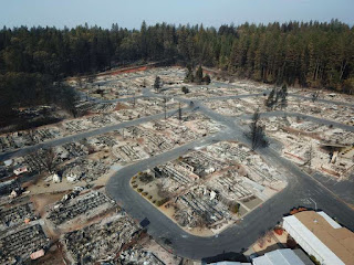
The towns of Paradise and Magalia in Northern California, nestled in the foothills of the Sierra Nevada, were once thriving communities with over 27,000 residents. On November 8th, 2018, the "Camp Fire" changed all of that within hours. Thousands have been affected by this wildfire, close to 100 people lost their lives, many thousands have lost their homes.

Aerial, Drone, Photo, Camp Fire, Disaster, GIS, UAS, UAV, GPS,

Over two days — hovering over the burned-out grounds of the state’s most destructive fire, a legion of drones began recording images of the devastation below in efforts to help the people who lost their homes. By the time they were done, they had collected 70,000 images over 17,000 acres resulting in 1.4 trillion pixels of data.

The detailed footage and maps would help people to determine the condition of their homes — and expedite insurance claims. The footage could also help recovery crews, demolition crews, city planners, scientists and researchers, and the general public, to get a better understanding of the situation. 

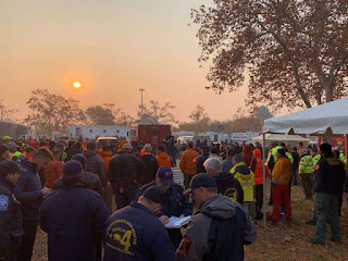
The 518 coordinated flights operation, by 16 Northern California emergency responder agencies, is one of the biggest drone response to a disaster scene in the nation’s history. The 16 UAV teams were led by Alameda County Sheriff's Office. Stockton Police, Contra Cost County Sheriff's Office & Menlo Park Fire Protection District had the most team members present, with Union City Police, Hayward Police and Stanislaus County Sheriff's Office providing units as well. San Francisco Police oversaw airspace mitigation. In addition to the mapping flights, over 160 full 360-degrees and interactive panoramas were created with the help of Hangar, as well as geo-referenced video was shot along major roads in Paradise through Survae. This layered data set was processed in record time. 

The photos and videos shot by drones were all georeferenced and stitched into a map format, making it possible for residents to check the status of their homes with the interactive AI app. Authorities in Butte County publicly released the maps and aerial photography even before many residents had been cleared to enter the fire zone to check their homes. Access Butte County's Camp Fire Map.

GIS, GPS, drone, uas, uav, wildland, fire wildfire,

We’re hoping that one, it will help people understand the devastation that we’re dealing with, understand the very difficult task that we have,” said Butte County Sheriff Kory Honea. “We’re hoping it’ll provide them information that will help them get their insurance claims started.”Read more