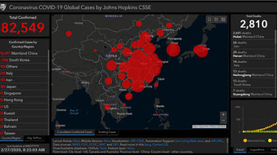
To help public health agencies and other organizations
jump-start their response to COVID-19, Esri is providing the ArcGIS Hub
Coronavirus Response template at no cost through a complimentary six-month
subscription of ArcGIS Online with ArcGIS Hub Basic. ArcGIS Hub is a framework
to build your own website to visualize and analyze the COVID-19 crisis in the
context of your organization's or community's population and assets.
Showing posts with label GIS. Show all posts
Showing posts with label GIS. Show all posts
Monday, April 6, 2020
Thursday, April 2, 2020
CivTAK4.0.1 Has Been Released & Its AWESOME
It will be interesting to see how the civilian version continues to develop and how well it will work in public safety and with drones.
CivTAK 4.0.1 has been released to the Public — “Public Release — Distribution Unlimited” in Government parlance. This is the first time that this enterprise-quality, mobile phone tools that the Government has spent hundreds of millions of dollars on has been available to the public, and it is FREE.
CivTAK 4.0.1 has been released to the Public — “Public Release — Distribution Unlimited” in Government parlance. This is the first time that this enterprise-quality, mobile phone tools that the Government has spent hundreds of millions of dollars on has been available to the public, and it is FREE.
CivTAK has most of the features of its military cousin, ATAK, which is used by hundreds of thousands of military and government users throughout the United States and the world.
Here’s a non-exhaustive list of features:
- Online or offline maps, including from customizable sources (but no limited license map sources like Bing or Google are supplied), and support for man, many map formats
- 2-D and 3-D mapping, including import of Pix-3D models from your drone
- Support for KML, KMZ and other geospatial overlays
- Elevation heat maps, elevation profiles, 3D views
- Ability to drop points, draw complex overlays, route following, measurement tools
- Integrate geo-photos, track recording, playback
- photo to map feature (Rubber sheeting)
- Map re-sectioning, to get your position without GPS (Old School mapping)
- Integrated radio controls supporting numerous radios for first responders (Firefighters, Police, Forest Firefighters, security guards, etc).
- Customizable toolbars
With radios or a server, such as TAKServer* — or a competitor like TeamConnect or TakLib**, you can also do the following:
- Team shared situational awareness (where are my friends), including chat, file sharing, pointer sharing,
- Geo-fences (Keep track of when something goes in/out of a defined area)
- Data packages (groups of files for complex scenarios)
- Video display with direct overlay,
- Emergency notifications
Wednesday, March 18, 2020
Multiple crews – and a drone – combine forces to rescue 2 hikers hours apart in Red Cliffs Reserve
ST. GEORGE — Two separate rescue operations in the Red Cliffs Desert Reserve kept emergency personnel, flight crews and search and rescue teams busy until late Tuesday night.
The first rescue was called in shortly after noon when a hiker suffered a fractured ankle while hiking the Church Rocks loop near Exit 13, a slickrock trail about 2.6 miles in length that rises to an elevation of more than 185 feet from the wash to the highest point on the ridge in the reserve.
The woman was hiking with a group who called 911 for help.
Washington City Police, as well as Washington City and Hurricane Valley Fire responded with ATVs to search for the injured hiker. Washington County Sheriff’s Sgt. Darrell Cashin said Washington County Search and Rescue was also called in to conduct a ground search, and Intermountain Life Flight was launched to provide aerial assistance. Read More
Do you have a story of drones coming to the rescue or
assisting your agency? Please share in the comments.
Monday, February 24, 2020
How GIS is Used in All Phases of Emergency Management
While EMMU Aerial specializes in drones for public
safety and emergency response, our initial background came from years supporting emergency
operations with geographical information systems (GIS).
GIS Lounge February 20, 2020
In this article from the GIS Lounge, Brian Sekita discusses how GIS is vital to all phases of the emergency management process.
GIS Lounge February 20, 2020
In this article from the GIS Lounge, Brian Sekita discusses how GIS is vital to all phases of the emergency management process.
Natural disasters such as hurricanes, floods, tornadoes,
earthquakes, and volcanic eruptions have impacted the globe since the beginning
of time. Technological improvements have exponentially improved the global
community’s ability to respond to the challenges presented by unexpected
disasters. Geographic Information Systems (GIS) is a framework for gathering,
managing, and analyzing data. Incorporating GIS into the disaster response
framework has improved planning, response times, collaboration, and
communication during the most challenging dynamic circumstances. Large scale
disasters require extensive amounts of geospatial information regarding regions
affected, infrastructure, and resource requirements. Developments in GIS have
provided agencies with the ability to collaborate more efficiently and
effectively. Emergency managers resolve natural disaster challenges using the
Comprehensive Emergency Management (CEM) approach. CEM is broken down into four
phases: mitigation, preparedness, response, and recovery (Agency, 1995).
Mitigation
Mitigation strategies prior to natural disasters are
essential to reduce loss of life and property by reducing the impact on
populations both within the U.S. and abroad. The Federal Emergency Management
Agency (FEMA), continuously works with local governments, states, and tribes
regarding hazard mitigation plans with short- and long-term focus. These
efforts have the overall intent of increasing education and awareness, building
partnerships for risk reduction, aligning risk reduction objectives, prioritization
of efforts, and to communicate priorities (FEMA, 2020). Flood hazard mapping
updates are part of the Risk Map program. This program identifies flood
hazards, assesses flood risks, and provides accurate data to stakeholders and
partners. These maps are dynamic and can be updated as terrain and
environmental conditions change. FEMA shares this data in publicly accessible
overlays powered by ArcGIS. In addition to flood mapping, overall mitigation
strategies are tracked using the same technology, with 87 percent of the
population currently residing in areas with approved mitigation plans (FEMA,
2020).
Preparedness
Emergency preparedness is the actions taken in advance
that develop operational capabilities, enabling a more efficient, effective
response to an emergency. One successful use of GIS during natural disaster
preparedness is the overland surge from hurricanes also known as the “SLOSH”
model, used by the US National Oceanic and Atmospheric Administration
(NOAA) (NOAA, 2020). SLOSH models use
current wind speed, distance, and direction in combination with precipitation
predictions and topography to determine possible locations at risk of flooding
during a storm. These efforts are critical to evacuation planning, leading to
more effective communication and decision making at all levels. NOAA provides
interactive open source National Storm Surge Hazard Maps for the US, Puerto
Rico / Virgin Islands, Hawaii, and Hispaniola.
The U.S. Army Corps of Engineers (USACE), supports
natural disaster response by providing subject matter experts in areas such as
engineering, biology, hydrology, geology, emergency management, real estate,
contracting, and geographical information systems experts. Together the USACE
staff supports FEMA’s emergency support function # 3 by providing technical
expertise, construction management, and reach back capabilities critical during
time sensitive real-world emergencies. Geographic information systems are a key
component utilized by USACE to communicate real time information in a context
that can be accessed by agencies collaborating to respond to time sensitive
missions. USACES employs GIS to produce sharable digital overlays with
information such as hydrologic and hydraulic models, flood inundation mapping,
consequences models, and data management. GIS development and coordination is
not only executed at the disaster site, but globally using the Modeling,
Mapping and Consequences Production Center (MMC) with SME’s across nine
districts globally (Dalton, 2018). An example of this occurred during Hurricane
Florence, where USAES played a critical role as part of the National Response
Framework (NRF). During this major hurricane, USACE and the MMC utilized the
National Weather Service (NWS) precipitation forecasts to develop flood mapping
to include simulations of operational releases of water from USACE dams and
impacts on levees within the threatened area (Dalton J. C., 2016).
Crowd Sourcing Example
Natural disaster information has traditionally been
obtained from National Mapping Agencies, news organizations, and emergency
agencies operating in the vicinity of the event. As technology continues to
connect the globe, the potential of crowdsourced geographic data has been
viewed as a powerful device to supplement authoritative data, when that data is
unavailable, outdated, or incomplete. During the research project, Evolution of
Emergency Copernicus services (E2mC), designers developed a component termed
“Witness” which enables data acquisition, analysis and storage. Emergency
management has successfully used this application in numerous real-world
emergencies such as the central Italy earthquake and the Haiti Hurricane of
2016 (Havas, 2017).
Recovery
The recovery phase occurs after initial relief has been
provided with the goal of returning property, society, and individual
livelihood back to normalized conditions. Recovery also allows government
organizations and agencies the opportunity to access natural conditions,
updating data and systems to represent geological changes that resulted from
the natural disasters. One such technology that enables a clear concise spatial
representation of the Earth’s surface is LiDAR or Light Detection and Ranging
(National Ocean Service , 2020). LiDAR was used during Hurricane Sandy, one of
the deadliest and most destructive hurricanes of the 2012 Atlantic hurricane
season. NOAA and USGS coordination enabled the collection of high resolution
topographic and bathymetric elevation data. The LiDAR data was utilized to
support studies aimed at hurricane recovery and construction, annotating
changes in the earth’s surface elevations due to storm surge, validate
storm-surge inundation predictions, and ecological assessments. Elevation data
developed by the Disaster Relief Appropriations Act of 2013 were added to the
3DEP and developed into NOAA’s “Digital Coast”, a centralized user friendly
information collection that is cost effective with high accuracy (GIS
Contributor, 2017).
Advancements in technology and the importance of
utilizing geographical information systems to aid in disaster response cannot
be overstated. GIS is vital to all phases of the emergency management process,
leading to a faster, more concise equipped response team. GIS integration into
disaster management enables higher levels of planning, analysis, situational
awareness, and recovery operations. The end state is economic savings,
increased collaboration and a safer population.
Thursday, July 11, 2019
Unmanned Aircraft Systems use on wildfires Miller Fire Wildfire
Miller Fire Wildfire News – 7/10/2019
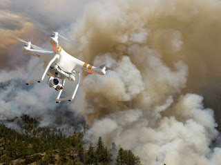
Unmanned Aircraft Systems (UAS) The National Interagency Fire Center is building an interagency fire Unmanned Aircraft Systems (UAS) program comprised of agency personnel and private contractors. The use of UAS is one way fire managers are incorporating new technology to support fireline decisions. This allows important information to be gathered quickly without putting firefighters in aircraft. UAS are broke down into 4 types based on their capabilities.A type 1 UAS is the most capable and type 4 is the least complex but the most portable.
Unmanned Aircraft Systems (UAS) The National Interagency Fire Center is building an interagency fire Unmanned Aircraft Systems (UAS) program comprised of agency personnel and private contractors. The use of UAS is one way fire managers are incorporating new technology to support fireline decisions. This allows important information to be gathered quickly without putting firefighters in aircraft. UAS are broke down into 4 types based on their capabilities.A type 1 UAS is the most capable and type 4 is the least complex but the most portable.
Agency personnel generally operate type 3 or type 4 UAS because they can be stored in a backpack and launched from the fireline. These smaller UAS operate at low altitudes, generally below 400 feet, have a battery life less than an hour, and must be operated within visual line of sight. If a fireline supervisor needs to get a better vantage point while on the line, they can launch these smaller UAS from their location and get the information back in real time. This also gives field personnel the opportunity to capture pictures of terrain and vegetation when scouting line. This information can be sent back to the incident command post for planning purposes.
Type 1and type 2 UAS are more complex systems that require more personnel and designated areas for launching. Flight crews for these larger systems can range from 3 to 9 or more crewmembers. Each of these personnel have important job responsibilities such as flying the aircraft, coordinating with ground and air resources, and interpreting data. These larger systems can fly to heights over 10,000 feet and operate for multiple hours. They can fly beyond visual line of sight and carry multiple cameras for mapping. On larger wildfires the Incident Management Team can utilize these larger “drones” for quicker turnaround times on infrared flights to identify heat along the fire perimeter.
The airspace above a wildland fire can be a complex environment with multiple fixed and rotor wing aircraft operating at different altitudes. Fire managers put a temporary flight restriction (TFR) over wildfires to maintain control of the aircraft within that space. In order to allow a UAS to climb through a complex airspace like this, fire managers use an area identified as a Launch Recovery Zone (LRZ). An LRZ is an area within the TFR that can be closed to other aircraft while the UAS ascends and descends. When an LRZ is “hot” no other aircraft can enter the space, once the UAS reaches its target altitude the LRZ is “cold” and other aircraft can fly through it again.
After landing, UAS data specialists support the operation by pulling the GPS data, photos and videos from the system to be interpreted and packaged for mapping. The data specialist can take pictures from the flight and georeference them on a map. This allows firefighters to get maps with updated aerial imagery to get an idea of burn severity or structures threatened. These larger drones also come with infrared (IR) cameras that can feed live IR information to the resources on the ground. This information allows firefighters to identify heat near the fireline so it can be suppressed before it escapes.
UAS operated by fire personnel are carefully coordinated with air and ground resources, it is important that the public remembers not to fly their own drones within the TFR of a wildfire. Individuals who are determined to have interfered with suppression efforts may be subject to civil penalties of up to $20,000 and potential criminal prosecution. Drone intrusions endanger the lives of firefighters, halt air operations, and impact the protection of values at risk.
If you fly, we can’t.
Saturday, May 25, 2019
GEO-Photo Oblique Aerial Photography
As I was looking back at where EMMU had come from and where
EMMU Aerial is today, it was obvious we had come a long way and learned a lot
along the way, mostly through our emergency mobile mapping and oblique aerial
photography systems.
From the early days of Emergency Mobile Mapping Unit or EMMU in 2000 where we provided a true mobile emergency GIS
response capability with our GIS quick response trailer to support wildland
firefighters, first responders and search and rescue
professionals. To the GEO-Photo System, with georeferenced oblique
aerial photography, providing invaluable, fast and accurate geographical
information and imagery for various government agencies. All well
before UAS or “drones” were even considered to be a viable tool of such information,
the GEO-Photo system had proven itself.
The GEO-Photo system primarily use was for handheld vertical
and oblique photography, captured from existing program aircraft for quick turn
geo-tagged intelligence photographs. For many emergency, police,
military and intelligence gathering operations, these crisp high-resolution
photographs with embedded GPS coordinates and associated GIS data was required
to conduct disaster response, mission planning and mission analysis for
emergency operations.
The GEO-Photo system was composed of a hand held high
resolution digital camera, GPS and gyro stabilizer. All with the
capability to record GPS latitude and longitude, elevation and direction data
within a high resolution digital still photograph. The camera system
was capable of storing several hundred photographs on compact flash
memory. But most importantly, this system was portable and not
mounted to any aircraft, capable of moving from aircraft to aircraft in the
hands of the operator. Today EMMU Aerial has drones for this
mission, but the legacy and capabilities of the GEO-Photo system are still
around.
Labels:
drone,
fire,
GIS,
GPS,
law enforcement,
public safety,
rescue,
SAR,
search,
UAS,
UAV,
wildfire
Location:
United States
Friday, March 29, 2019
Search and rescue team uses new UAS to find, remotely communicate with lost Gila kayaker
LAS CRUCES — The Mesilla Valley Search and Rescue team used new equipment to help rescue a lost kayaker in the Gila this weekend.
The search team used a DJI Mavic 2 C, or unmanned aircraft system, to locate a missing kayaker, and to communicate with him until help arrived.
The call for assistance came in just after midnight Sunday.
"It's one of the most difficult searches we've been on," said chapter President Vic Villalobos on Tuesday.
The 25-hour mission to find a person lost while kayaking the Gila River began with team members hiking five or six miles through rocky, thorny and steep terrain, before reaching its first search area. There, the Gila includes deep valleys and steep canyons, said Aaron Marquez, one of two UAS pilots on the search team.
"We were able to fly at higher elevation and use the camera equipment to zoom into the canyon without having to fly into the canyon," Marquez said. Read More
Labels:
drone,
GIS,
GPS,
Missing Person,
public safety,
rescue,
river,
SAR,
search,
swiftwater,
UAS,
UAV,
water
Location:
Las Cruces, NM, USA
Monday, December 3, 2018
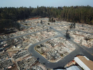
Mapping Camp Fire Disaster with Drones
DJI November 2018
DJI works with 16 first response agencies for disaster
response and damage assessment for California’s deadliest wild fire
The towns of Paradise and Magalia in Northern California,
nestled in the foothills of the Sierra Nevada, were once thriving communities
with over 27,000 residents. On November 8th, 2018, the "Camp Fire"
changed all of that within hours. Thousands have been affected by this
wildfire, close to 100 people lost their lives, many thousands have lost their
homes.
Over two days — hovering over the burned-out grounds of
the state’s most destructive fire, a legion of drones began recording images of
the devastation below in efforts to help the people who lost their homes. By
the time they were done, they had collected 70,000 images over 17,000 acres
resulting in 1.4 trillion pixels of data.
The detailed footage and maps would help people to
determine the condition of their homes — and expedite insurance claims. The
footage could also help recovery crews, demolition crews, city planners,
scientists and researchers, and the general public, to get a better
understanding of the situation.
The 518 coordinated flights operation, by 16 Northern
California emergency responder agencies, is one of the biggest drone response
to a disaster scene in the nation’s history. The 16 UAV teams were led by
Alameda County Sheriff's Office. Stockton Police, Contra Cost County Sheriff's
Office & Menlo Park Fire Protection District had the most team members
present, with Union City Police, Hayward Police and Stanislaus County Sheriff's
Office providing units as well. San Francisco Police oversaw airspace
mitigation. In addition to the mapping flights, over 160 full 360-degrees and
interactive panoramas were created with the help of Hangar, as well as
geo-referenced video was shot along major roads in Paradise through Survae.
This layered data set was processed in record time.
The photos and videos shot by drones were all
georeferenced and stitched into a map format, making it possible for residents
to check the status of their homes with the interactive AI app. Authorities in
Butte County publicly released the maps and aerial photography even before many
residents had been cleared to enter the fire zone to check their homes. Access
Butte County's Camp Fire Map.
We’re hoping that one, it will help people understand the
devastation that we’re dealing with, understand the very difficult task that we
have,” said Butte County Sheriff Kory Honea. “We’re hoping it’ll provide them
information that will help them get their insurance claims started.”Read
more
Tuesday, May 29, 2018
Colorado search and rescue teams are using drones to find lost adventurers
To more efficiently manage already limited resources, volunteer search and rescue teams across the state are now using drones as their eyes in the sky.
Labels:
drone,
GIS,
GPS,
Missing Person,
public safety,
rescue,
SAR,
search,
UAS,
UAV
Location:
Colorado, USA
Friday, January 26, 2018
Training - Small Unmanned Aircraft System (sUAS) Basic Remote Pilot Course for Public Safety
Course Description:
Once again, EMMU Aerial is offering the popular (sUAS) Basic Remote Pilot Course. This is the fundamental sUAS course for individuals wanting to become qualified to operate sUAS for a Public Safety Agency. The sUAS course will utilize small sUAS aircraft to provide the basic academic and flight training necessary to conduct missions as Remote Pilot-in-Command (RPIC).
UAS can positively impact every element of your agencies by utilizing state of the art equipment. UAS derived data and imagery empowers firefighter, law enforcement, incident personnel, and senior leaders to make informed decisions based on precise and real-time information. Data gathered from UAS is unique due to the ability of the aircraft to fly low, slow, and for long periods of time while collecting high-resolution imagery.
The Basic Remote Pilot Course is designed to qualify students to safely operate a sUAS in the field environment and capture video/stills of a point of interest with multirotor aircraft and applicable sensors.
Course Prerequisites
Must obtain FAA Part 107 Remote Pilot Certificate at least
two weeks prior to class. Students should expect to show a physical copy of
their certificate to an Instructor.
Date; April 16, 2018
Length; 32 hours
Location; Volusia County, Florida
Contact EMMU Aerial for more information and to enroll
Monday, December 18, 2017
L.A. Fire Department used drones for the first time during Skirball fire
The Los Angeles Fire Department dispatched drones for the first time while battling a wildfire this month as firefighters took on the Skirball fire in Bel-Air.
Fire officials demonstrated the use of the unmanned aerial vehicles for reporters on Thursday, sending two drones buzzing near blackened hills around Linda Flora Drive.
“They provide real-time situational awareness from a bird’s-eye perspective to the incident commander so they can see what’s going on at their emergency and then change their tactics accordingly to mitigate the hazards,” said Capt. Erik Scott, an LAFD spokesman. Read More
Monday, November 20, 2017
Drones are fighting wildfires in some very surprising ways
Bad as they are, the wildfires now raging in southern California aren't exactly unprecedented. Wildfires in the U.S. were brutal last summer too, scorching more than 8.8 million acres and cloaking the Pacific Northwest in smoke and ash. In California alone last year, more than 40 people died and 8,400 buildings were destroyed in the deadliest wildfires in the state’s history.
Things may only get worse in years to come. Climate change is lengthening fire seasons and triggering more and larger blazes.
But aerial drones may help save the day. In fact, the Los Angeles Fire Department today said it would use firefighting drones for the first time in its history to coordinate the effort to help extinguish a pair of fires threatening homes in the city. Read More
Wednesday, October 18, 2017
Case Study: Wildfire Hot Spot Mapping with a Thermal Imaging Drone
Using Drones to Combat Wildfires
The Canadian province of British Columbia has experienced the worst wildfire season in recorded history. Over 2 million acres have been burned, and at its peak, 45,000 people were displaced.1 The British Columbia Wildfire Service (BC Fire) deployed every available resource, including four types of fire crews, 24 fixed-wing aircraft, 6 helicopters, and out-of-province resources.2 This year, BC Fire tested a new tool: drones.
Drones equipped with thermal infrared cameras can see hot spots in the forest that are primed for ignition, as well as areas that may have escaped containment. In some cases, roots may smolder for several days beneath the ground surface. If hot spot locations are provided to the fire crew in a timely fashion, they can cool or extinguish them to prevent further spreading. It is also critical to “clear” the area before civilians are allowed to return into an evacuation zone. Drones excel at mapping and data collection, which frees up larger wildfire aviation assets to deploy crews, move equipment, and drop flame retardants and water onto the wildfire. Read More
Saturday, February 11, 2017
Training - Field Applications of GPS / GIS for Fire Management
EMMU Aerial is once again offering their popular course on Field Applications of GPS / GIS for Fire Management.
Course Objective: Provide Fire Management Staff with a
working knowledge of the use of Global Positioning System (GPS) receivers for field mapping
applications.
Lesson Objective:
·
Understand how the Global Positioning System
works
·
Understand differences and capabilities of
various GPS Units (overview)
·
Understand the use of Datum’s, Coordinate
Systems, and projections
·
Understand real time GPS differential correction
·
Learn how to set-up and operate the GPS Unit(s)
·
Learn to manage the sources of GPS error
·
Be able to plan and perform a mission. Identify
objectives, organizing / selecting appropriate receiver, complete equipment,
which datum or coordinate system to use
·
Enable students to collect waypoints, track logs
and download data
·
Expose students to digital mapping software and
real time communication interface.
·
Enable the students to post-process their field
data.
· Enable the student utilizing ArcView, to overlay collected data onto appropriate aerial photo (DOQQ), or quad map DRG, and determine acreage.
· Enable the student utilizing ArcView, to overlay collected data onto appropriate aerial photo (DOQQ), or quad map DRG, and determine acreage.
·
Enable students to determine appropriate ArcGIS layout and print.
·
Enable student to be able to hand-off data to
GIS Specialist
·
Include practical aerial mapping exercise (helicopter)
Date; April 14, 2017
Location; Orlando, Florida
Registration; Contact Dave Crago at cragod1@gmail.com
Location:
Orlando, FL, USA
Friday, December 16, 2016
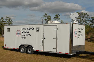
EMMU Mobile Emergency Response GIS / GPS Mapping Trailer and Geo-Photo
As I was looking back at where EMMU had come from and where
EMMU Aerial is today, it was obvious we had come a long way and learned a lot
along the way, mostly through our emergency mobile mapping and oblique aerial
photography systems.
From the early days of Emergency Mobile Mapping Unit or EMMU in 2000 where we
provided a true mobile
emergency GIS response capability with our GIS quick response trailer to
support wildland firefighters, first responders and search and rescue
professionals.
Read more about the original concept of the EMMU mobile emergency response GIS / GPS mapping system
Read more about the original concept of the EMMU mobile emergency response GIS / GPS mapping system
During an emergency or crisis, maps play a critical role
in responding to the event, search and rescue, mitigating further damage, and
understanding the extent of the impacts. Geographic Information Systems (GIS)
is an appropriate platform to organize the extensive amount of spatial data
both generated and utilized during an emergency event. A properly designed and
implemented GIS will allow managers and responders to access critical location
data in a timely manner so lives and property can be protected and restored.
GIS works effectively in all four phases of the disaster
management cycle; preparation, mitigation, response and recovery.
GIS can play a
valuable and vital role in;
• Hurricanes
• Tornadoes
• Floods
• Wild
Fires
• Earthquakes
• Volcanoes
• Tsunamis
• Landslides
• Search
and Rescue
• Epidemics
• Social
unrest
• Toxic
spills
EMMU GIS Trailers are capable of quickly and efficiently
compiling, processing, managing and printing raw data points onto either
full-size 36" or 42" color plots, or on easy to distribute
11"x17" pages. The EMMU GIS trailers also have the ability to project
maps inside the trailer for emergency managers to quickly survey and understand
an ever changing situation. EMMU has top-of-the line hardware, current ESRI GIS
software suites, and experienced specialists to provide a GIS solution that
will exceed expectations for quality and speed of service.
Opportunities for Mobile GIS Systems end with the limits
of your imagination. These systems are ideal for emergency management, private,
corporate, county and industrial research where onsite mapping technologies and
experienced GIS / GPS specialists can save time and cut costs considerably
EMMU GPS Specialists can also assist the incident
commander by providing GPS, GIS data integration. GPS is one of the most
efficient methods for documenting information regarding the location of
facilities, conditions, and environments affected by Wildfire, Floods,
Earthquakes, and other incidents.
EMMU GIS units are dispatched out of Central Florida with
a fully qualified GIS/GPS Specialist.
Additional GIS /GPS Specialists are available upon request
Standard GIS Unit Features
• 8.5 x
24 ft Self contained climate controlled trailer
• Meets
OSHA work environment requirements
• Workspace
for a minimum of 3 workers
• AC
power source (Generator)
• High
Speed Satellite Internet Connection
• UPS
and line conditioner system
• All
workstations, printers and plotters are networked
• 1 Xeon
3.0 MHz Desktop
• 2 Core
2 Duo Mobile Desktops
• HP 800
PS Large Scale Plotter
• HP
9600 11x17 Printer
• Laser
copier, printer, fax, scanner
• Multiple
GPS units
• 4x4
ATV with GPS (Optional)
Installed software includes
• ESRI ArcGIS
9.1 and 9.2
• ESRI ArcView
3.3
• Spatial
Analyst
• Fire
Incident Mapping Tool
• Ventura
Tools
• DNR
Garmin GPS software
• Adobe
Photoshop
• Microsoft
Office
EMMU Inc. also offers Oblique Aerial Photography; we use
a professional-grade digital camera with top of the line lenses. The resulting
images can be filtered to remove moderate smoke/haze, and enhanced to identify
vegetation types. We also utilize Gyro-stabilizing equipment to keep the camera
still at the moment the photo is snapped. Thanks to this added stabilization,
photographs taken from an airplane or helicopter do not contain the blur seen
on many photos. When needed, these cameras can be coupled with a GPS to provide
the Latitude and Longitude coordinates in the photo data and on the photo if
needed.
Years later, EMMU Aerial had developed their skills through extensive operational aerial photography, remote sensing and UAS surveillance work with the military and government agencies. From these beginnings with military systems, we now provide turnkey and flexible training solutions and services for public safety agencies and organizations throughout the U.S.
Subscribe to:
Posts (Atom)
-
While looking back at some recent search and rescue operations that utilized drones, I came across a rescue on January 20 th and an earlier...
-
Over the years, EMMU Aerial has helped countless drone pilots in passing their aeronautical knowledge test to get an FAA Part 107 Remote Pil...
-
Aloft Technologies, Inc. (Aloft), a leader in advanced drone software solutions, is thrilled to announce the integration of Automated Spec...

