Thursday, April 30, 2020

FAA Announces Regulatory Relief Updates for Part 107 Recurrence Exam Testing

FAA, drone, uas, uav, testing, test, covid, coronavirus, training, 107, part,

Update; This was filed to day and is scheduled to be published in the Federal Registry on May 4, 2020.

April 29, 2020

The FAA has published a wide-ranging Special Federal Aviation Regulation (SFAR) (PDF) that provides regulatory relief to pilots, crew members and other FAA certificate holders who have been unable to comply with certain training, recency-of-experience, testing, and checking requirements due to the COVID-19 public health emergency.

In Summary; Under the extraordinary circumstances of the COVID-19 outbreak, eligible remote pilots who would normally establish recency of knowledge in accordance with §107.65(a) or (b) may complete online training as an alternative if required to establish recency between April 2020 and June 2020. The remote pilot may complete the FAA-developed initial or recurrent online training courses at www.faasafety.gov one time to establish knowledge recency for six calendar months.

However, because the courses do not include all of the knowledge areas that a remote pilot is required to be tested on every 24 calendar months, the remote pilot will need to establish knowledge recency in accordance with §107.65 at the conclusion of the six calendar months.

Here is what you will need to do;

Register at www.faasafety.gov.

Enroll in either;

ALC-451 Part 107 Small Unmanned Aircraft System (small UAS) Initial
ALC-515 Part 107 Small Unmanned Aircraft Systems (small UAS) Recurrent

It will take approximately 2 hours to complete this material, to include; introduction, course content, downloadable reference materials, course review and the take the test.

Remember, this test is for drone pilots that need to take their recurrent knowledge test between April 2020 and June 2020 only.  The renewal is only temporary and will authorize you to operate a small unmanned aircraft system under Part 107 for a duration of six calendar months from the month in which the you completed the online training course.  You must take and pass your standard Unmanned Aircraft General (UGR) test before those 6 months are up.   

Please review the complete text from the FAA’s COVID-19 Relief if you have further questions.

Thursday, April 23, 2020

What are the Benefit of Oblique Aerial Drone Imagery for Search and Rescue?

Have you ever thought of collecting oblique videos for search and rescue?  Watch this great video from 2018 where Jon McBride VP of Technology at RMUS discusses an alternative drone search technique for searching in heavy vegetation and or terrain.  The technique involves the drone flying a pattern collecting video vs still images with the camera in an oblique position vs nadir.  Let us know what you think in the comments section below.


Saturday, April 18, 2020

High-altitude drone captures rare view of Mount Everest


I'm amazed that Renan Ozturk pulled off photographing Everest in a stunning 360-degree panorama by drone at 23,000 ft in 2019.  It's an incredible achievement considering the odds against him. Extreme wind, elevation, and cold are often no goes for a drone to fly.  From what I understand, it was a Freefly Alta X , drones like this aren't typically designed to fly half that elevation. Cold batteries don't produce enough lift for safe takeoff. And drones will not come back if the wind exceeds the drone's max airspeed. I lost one this way.

drone photograph, everest, mountain, panorama, alta x,
Click on image for larger photo

Wednesday, April 15, 2020

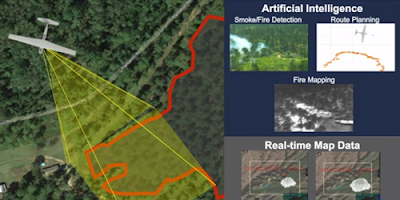
IBM, Microsoft, Aerovironment and Nvidia Pit AI Against Wildfires


AeroVironment has been working with Nvidia and Microsoft to deliver a prototype AI-enabled system that could help bring advanced wildfire management.

Aerovironment, wildfire, wildland, fire, drone, uas, uav

 In 2018, California experienced its worst wildfire season on record, with uncontrolled fires causing unprecedented death and devastation. 2019 saw another difficult season, with millions of residents experiencing precautionary power shutoffs. With much of the world self-quarantining and the 2020 fire season looming, Nvidia’s virtual GTC 2020 hosted a panel highlighting how AI practitioners are working with forest stewards to bring fire management into a new, data-enabled era.

Firewatch duty was traditionally served by fire lookouts on towers overlooking forests, but moving that role into the 21st century is easier said than done. In order to be truly useful to first responders in a wildfire, an AI model needs to be able to detect smoke – not fire – very, very quickly. After all, by the time a fire is large enough to be easily spotted, it’s typically less containable, and if the smoke is reported too late to act on it, the fire will have had substantial time to grow.  Read More


Tuesday, April 14, 2020

A “UAS Primer For Public Safety”, Public Aircraft Ops vs Part 107

FAA, public. safety, aircraft, part 107, operations,

The linked information below dated January 2020 was provided by the FAA as a courtesy to public safety entities looking to get operational with Unmanned Aircraft Systems (UAS), and is a compilation based on many conversations the FAA Public Safety team has had with successful and highly reputable UAS practitioners.

The information is provided as an aid to public safety entities looking to get operational with drones; to help them understand what to do to operate safely in the National Airspace System. This information shall not be construed as official FAA guidance, regulations, or policy, which are contained in other official documents.

Go to the complete; FAA UAS Primer For Public Safety

Sunday, April 12, 2020

Overcoming the Challenges of Starting a Public Safety Drone Program

Lynwood Fire Department Shows the Value of Drones for Small to Mid-Sized Agencies

DJI Enterprise April 4, 2020  
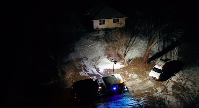
In the fall of 2017, in Peru, Illinois, an armed suspect has barricaded himself inside a suburban home after firing at police officers. The apparent suspect’s emotional instability, the fact that the suspect was former military with explosives experience and the threat he made of placing IEDs around the house are making the situation worse. Well over 150 public safety personnel surround the house. Fortunately for the tactical teams and emergency response crew, the suspect is willing to negotiate.

Calling for Help

As the day wore on, the incident commander knew that the coming night would only complicate the situation. He asked his team what options they had. Chief Ed Rogers, of the Utica Fire Department, immediately thought of the Lynwood Fire Department and their UAS operations program. Thermal imaging paired with a clear aerial view of the house would provide acute situational awareness in case the suspect made a run for it. 

After receiving the call, Keenan Newton, Lieutenant and UAS coordinator of the Lynwood FD, arrived on site before dusk. As he and his team began unloading their equipment, the suspect told the negotiator that his phone was low on battery. Negotiators knew they had to keep talking with the suspect to help ensure a peaceful outcome. It was a tense moment. Everyone anticipated the situation intensifying unless the suspect was provided a new phone. Something had to be done.

The first attempt to deliver a phone with a law enforcement robot failed. As it had a technical failure. The incident commander looked at Chief Rogers and asked if the phone could be delivered with a drone. “Of course we can, we’re firemen,” Chief Rogers responded.

Keenan got to work immediately. Utilizing a drop release system, a remote-controlled drop mechanism used for deliveries, on a DJI M600 Pro drone, he would attempt to swing the phone into the suspect’s bathroom window. Two Inspire 1 drones were flown nearby to help spot and guide the drop, as well as record the delivery. The cell phone was tied to a rope, and within minutes the drone was hovering over the house. Approaching carefully, Keenan successfully positioned the cell phone just outside of a window and swung it towards the bathroom window until the suspect grabbed it. 

public safety, drone, uas, uav, program,

Friday, April 10, 2020

Search And Rescue Teams Use Drone To Help Injured Hiker - How Does Your SAR Team Utilize Drones?

While looking back at some recent search and rescue operations that utilized drones, I came across a rescue on January 20th and an earlier one in December in Snow Canyon State Park, Utah.  Read on about a couple of methods used by search and rescue crews.  

drone, uas, uav, rescue, sar, team, search, public safety,
Photo from video by: Mike Thomas

Snow Canyon State Park, Utah, a drone helped rappel a hurt hiker more than 400 feet during a daring rescue in Snow Canyon State Park Sunday.

It’s the first time the Washington County Search and Rescue team used a drone this way, but likely won’t be the last.

Search crews helped a 65-year-old woman who got hurt hiking on the top of Island in the Sky around noon. She had fallen several feet and could not put weight on her foot.

To bring her down, they’d need to be creative.

“We were trying some different ideas,” Darrell Cashin said.

The problem? It would take four men to carry up the rope needed to rappel the woman down nearly 40 stories.

A special gun that launches the rope up fell about 100 feet short.

So they put 660 feet of twine on a drone and sent it up.

“We gave that a shot and it actually worked,” Cashin said. “The canister was light enough for the drone to handle, didn’t have too much wind and so we flew the drone all the way up to where the guys were literally right to their hand. Disconnected that, flew the drone back down.”

At the bottom of the mountain, the twine was attached to the main rope and was pulled up the bluff.
“They just rappelled her off down to there and we carried her out,” Cashin said.

In December, a drone was used as a spotlight to help rescuers see better in the dark while helping a lost hiker on the same mountain.

The drones also help spot lost hikers, send messages and transport small items such as a radio or bottle of water, according to Cashin.

“We are finding new ways to utilize them and find their capabilities and limitations and new things we can do with them," Cashin said.

Three other people who were with the injured woman also rappelled down the bluff with the help of rescuers.

Has your SAR team found any new ways to utilize drones in search and rescue, tell us about it in the comments?

Thursday, April 9, 2020

Above SoCal, NASA and GA fly SkyGuardian to prove UAS ability

Above SoCal, NASA and GA fly SkyGuardian to prove UAS ability @UASMagazine: NASA’s goal to help accelerate routine UAS operations into the national airspace has moved one step closer with this successful flight demo, according to NASA officials.


Wednesday, April 8, 2020

Daytona Beach Police Using Drones To Enforce Coronavirus Closures

ClickOrlando.com April 7, 2020
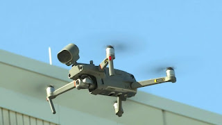
DAYTONA BEACH, Fla. – The Daytona Beach Police Department is now equipped with two more drones to add to its six, but the loaner drones police are using to enforce closures and other social distancing measures during the coronavirus pandemic are equipped with intercoms.

police, drone, uas, uav, covid-19, coronavirus, daytona,

Drone company DJI loaned the drones to the department through a disaster relief program. Police said the flying pieces of equipment will help them disperse crowds and keep people out of all city parks, which are temporarily closed to help prevent the spread of COVID-19.

“We’re reducing the officer having to go out there, walk into the park property, walking into a crowd of people, share those germs back and forth just to deliver a message that, 'The park’s closed. Don’t be in here,’” said Sgt. Tim Ehrenkaufer, who heads the department’s Unmanned Aviation Systems Unit.

The department showed drone footage from one of its 30 missions over the last week. The video shows people leaving parks throughout the city and Ehrenkaufer said people fully complied. Police also demonstrated their own $27,000 drone that’s equipped with a drop hook feature that officers use in situations similar to when a beachside bomb threat was reported last year. Ehrenkaufer said it’s also helpful to drop off lifesaving materials.

“That could be anything from the life preserver that you’ve seen us drop into the lake, to somebody drowning, to a box of gloves, medication,” he said.

That same drone also has a FLIR cam that can read a person’s body temperature. Police said they will be discussing if it should be installed in their front lobby to help minimize the spread of COVID-19.

“Let’s say if you have a 103 fever, that will come in handy with letting us know from at a glance, are you somebody who possibly has the virus?" Ehrenkaufer said. "Do we need to make sure you have extra precautions and make sure that you have the extra equipment that you need?”

The department hopes the two loaner drones will officially be theirs in the future because it could possibly be another protective layer for an officer's safety.

“I think in terms of keeping officers safe, I think it’s very important,” Ehrenkaufer said.

Monday, April 6, 2020

UAV Deployments in Disaster Relief Webinar

Best practices for deploying UAVs in disaster relief scenarios, including the COVID-19 response

Attend this webinar to learn how public safety agencies have been assessing new relief measure that integrate drones into their workflows during a crisis.

When; 11 AM PDT, Wednesday, April 15, 2020

dji, drone, uav, uas, disaster, relief, public safety,

How are drones impacting disaster relief efforts by public safety agencies across North America and the globe? Find out from DJI’s public safety experts on how this technology is currently being used, what methods have been tested in the field throughout the United States, and what this could mean for efforts in combatting the COVID-19 pandemic.

Romeo Durscher, Senior Director of Public Safety Integration at DJI, and Wayne Baker, Director of Public Safety Integration at DJI, will be discussing how agencies have been assessing new relief measures that integrate drones into their workflows during a crisis.

Here’s what to expect:
·         Applications of drone technology by public safety agencies in previous disaster relief efforts
·         A view of how nations across the world are using drone technology amidst the pandemic
·         A review of the use cases that have been implemented in North America so far and which ones are proving to be effective
·         Looking ahead to how this could impact future disaster responses
·         Open Q&A period

Request Emergency GIS Help From The ESRI Disaster Response Program for COVID-19


To help public health agencies and other organizations jump-start their response to COVID-19, Esri is providing the ArcGIS Hub Coronavirus Response template at no cost through a complimentary six-month subscription of ArcGIS Online with ArcGIS Hub Basic. ArcGIS Hub is a framework to build your own website to visualize and analyze the COVID-19 crisis in the context of your organization's or community's population and assets.


dis, esri, gps, covid-19, coronavirus, disaster, response,

Sunday, April 5, 2020

Drone shots show New York's Javits Center as a makeshift hospital

TV Houston April 4, 2020
New York City Emergency Management on Friday (April 3) released drone footage of the Jacob K. Javits Convention Center, a venue used by New York Comic Con and the New York International Auto Show, as a makeshift hospital.

The U.S. military and federal personnel will operate the hospital to help the city grapple with a flood of COVID-19 patients.

New York has become the epicenter of the U.S. epidemic with more than 47,000 confirmed cases in the city.


Anchorage Police use drone to find missing hiker

KRCR TV  April 5, 2020
Police in Anchorage, Alaska, deployed a drone to help them locate a hiker who had gone missing in a wooded area on Saturday, March 28.

According to police, dispatchers received a call from a woman who went off-trail in a wooded area and was no longer able to see her footprints in windy conditions.

Police sent officers who were in the area to find the woman on foot, while another officer sent up the drone. Once deployed, the drone located the woman within 15 minutes, using an infrared camera. The drone officer was able to tell the woman his colleagues were on the way. “She was really happy to hear the mysterious voice in the sky,” police added.

“All’s well that ends well! We got her out safe and sound,” police wrote.  See video


Do you have a story of drones coming to the rescue or assisting your agency?  Please share in the comments.

Watch as Nottinghamshire Police find missing boy, 12, with help from drone team

Nottingham Post April 4, 2020
Police located a 12-year old boy who had gone missing overnight - thanks to help from the force drone team’s ‘eyes in the sky’.

Officers began their search for the boy after he was reported missing just after 8pm from the Oxton area of Nottinghamshire on Saturday, April 4.

The force’s drone team were deployed to help officers soon after, with the drone’s pilot helping to direct officers to the boy who was found safe just over an hour later.

Video shows the drone hovering above when it picks out the boy in the dark.

The drone team help fellow officers on the ground by supporting everything from drug warrants and river rescues to policing large-scale football matches.

Nottinghamshire Police’s Deputy Chief Constable, Rachel Barber, said: “In the short time that the team have been in the sky, they have proved to be invaluable in supporting officers on the ground and the drones are now a vital part of operational policing in our county where it genuinely is making a difference each and every day.

“This incident is yet another success story for the team and, in this case, it has given us the edge in helping to locate someone who we had genuine concerns for the safety of much sooner than had we been relying solely on traditional search techniques.”


Do you have a story of drones coming to the rescue or assisting your agency? Please share in the comments.

Friday, April 3, 2020

First Responders Assess Drones for Search and Rescue Missions

Drones buzz like bees, hover like hummingbirds, and accelerate like race cars. Besides being used for play, drones, properly known as unmanned aircraft systems (UAS), have quickly become vital pieces of technology for both private and public organizations. First responder organizations rely more and more on them to enhance their response capabilities and better execute their missions. But how can first responders be sure the drones they are buying meet their specific mission needs?

The Department of Homeland Security (DHS) Science and Technology Directorate (S&T) can help.

In November 2019, S&T’s National Urban Security Technology Laboratory (NUSTL) assessed small, commercially available drones for priority needs of first responders through its First Responder Robotic Operations System Test (FRROST) program. The needs were identified by the S&T First Responder Resource Group (FRRG), a volunteer working group of experienced emergency response and preparedness professionals from across the U.S. who guide research and development efforts. The assessment was performed under realistic field conditions at Camp Shelby Joint Forces Training Center in Mississippi.

“We are focused on the first responder community – fire, police, and emergency management departments – and we are assessing small UAS,” said Cecilia Murtagh, FRROST Project Manager. “They are much cheaper than manned aircraft, which makes them an ideal tool for response agencies.”

public, safety, drone, uas, uav, first, responders, dhs,

Background
S&T initiated the FRROST program in 2018 to help the first responder community evaluate drones in real-world field conditions under simulated scenarios to inform their purchases. FRROST is modeled after S&T’s System Assessment and Validation for Emergency Responders (SAVER) Program, managed by NUSTL. It assists emergency responders in making procurement decisions by producing reports based on objective assessments and validations of commercially available technology. FRROST focuses on drone technology and uses assessment methods developed by the National Institute of Standards and Technology (NIST).

In June 2018, a focus group of first responders, experienced in piloting drones for different missions, convened to provide evaluation criteria for the FRROST assessment. The focus group selected several drones to be tested and evaluated in realistic field conditions.

Becoming the ‘right hand’ of first responder organizations
D.J. Smith from Virginia State Police operates the remote control of a Falcon 8+ drone by Intel. Small drones offer tremendous potential for emergency response missions. Thanks to recent technology advances, they have become more effective, more affordable and easier to fly. They can not only keep responders safer, but also provide opportunities for missions impossible for manned aircraft, such as exploring inside buildings and tunnels.

“Drones are a force multiplier for first responders,” said Murtagh. “It gives them eyes on a situation quickly with generally less manpower; for example, you could fly a drone over diverse terrain or wide areas and try to find a lost hiker, which would be labor intensive for field teams.”

Law enforcement responders use drones for tactical operations, building searches, traffic crash investigation, pursuit, and more. For example, the Plano, Texas Police Department used a drone to look for an armed suspect hidden in an apartment complex.

“The subject was actually firing rounds out of the apartment, so we couldn't get close enough to look in,” said Lieutenant Glenn Cavin of the Plano Police Department. “The UAS was able to look through the window and provide intelligence.”

After floods, emergency managers use drones to survey actual damage, so they send help where it is actually needed without risking responders’ lives.

“We have launched our drone to find a missing older adult,” said Randy Frank, Director of Marion County, Kansas Emergency Management. Small counties like Marion use the same drones for multiple missions. “Drone use is only limited to your imagination.”

Large counties like Orange County, California, need different drones for their various terrains, including metro city, wildland-urban boundary, harbors and more.

Tom Haus from the Los Angeles City Fire Department sets up video to capture the operator interface while the participants fly the NIST Test Methods.“During a brush fire, a drone can map out where the hot spots are, thus helping the firefighters to put that hot area out,” said Frank Granados, Firefighter Paramedic at the Orange County Fire Authority, CA.

First responders assessed drones at Camp Shelby
In November 2019, nine first responder drone pilots from across the U.S., some of whom are quoted in this article, assessed four small drones in fields and mock urban settings at Camp Shelby. The drones weighed between 1.9 and 13.5 pounds. The pilots, with law enforcement, firefighting and emergency management backgrounds, participated in three different search and rescue scenarios: lost hiker (in an isolated field), post-flood disaster (in the urban setting and an adjacent field) and a twilight scenario (in the urban setting). The drones demonstrated different capabilities and participants provided feedback to NUSTL after taking turns flying them. NUSTL coordinated with NIST for this testing event, using a test course that NIST developed for drone assessment and pilot training and testing.

“All participants are getting an opportunity to run the drones through those standard test lanes to see how they match up against what they would like to see in a mission ready, small unmanned aerial system,” said Captain Tom Haus of the Los Angeles Fire Department, who assisted NIST with FRROST’s standard testing and scenarios.

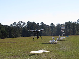
Falcon 8+ drone hovers over a car with a cluster of NIST buckets to look for ‘stranded flood victims,’ as part of the FRROST search and rescue scenario.Wooden stands stood in a wide field next to the urban setting at Camp Shelby. Clusters of white two-gallon buckets like giant bell-shaped blossoms adorned the stands. Other clusters were attached to windows, roofs, and even a car. Inside each bucket on the bottom was a sticker with a letter surrounded by a circle. Such stickers could be seen on other parts of the buckets and poles. The drones had to hover over each bucket, like honeybees over a flower, and take accurate pictures.

“These visual acuity tests, just like the eye charts at the eye doctor, are designed to allow the operator to align his/her small unmanned aerial system with that bucket” said Haus. “If you are not aligned, the bucket itself keeps you from seeing into the bottom.”

Participants assessed how well the drones could be stabilized, how easily they could be flown, and how well their payloads functioned. Payloads included 30x zoom cameras for distant visualization and thermal cameras for twilight and night.

During the twilight testing, drones demonstrated their thermal imaging cameras and participants watched on a monitor what the drone was ‘seeing.’ One of the pilots moved the drone vertically, hovered it over the car, a roof and in front of a window, all with clusters of buckets. This simulated how a drone could be operated to look for survivors after an emergency or disaster, such as a hurricane.  

NUSTL representative Cody Bronnenberg (right) records feedback from UAS Trainer Coordinator Christopher Stockhowe (left) from the Virginia Beach Fire Department after he flew the EVO drone by Autel Robotics.FRROST took place over four days, with a different drone assessed each day. A large drone with a 42-megapixel camera and an infrared camera was tested during the last day. It was designed for professional inspection and surveying of bridges and other areas. The first responder evaluators determined that it could be paired together with a smaller, faster drone. In this scenario, the evaluators used the large drone for overall incident awareness and then used a smaller drone for closer inspection.

Future outlook
The feedback provided by participants in the FRROST event will be documented in a final assessment report and shared nationally with the first responder community. NUSTL’s report will provide unbiased results that can help first responder organizations with their procurement decisions.

Moving forward, another S&T project called Joint Unmanned Systems Testing in Collaborative Environment, or JUSTICE, assesses drones and sensors for the Homeland Security Enterprise. JUSTICE is managed by the S&T Air Based Technologies Program and a team of experts from the Mississippi State University Raspet Flight Research Laboratory.

“Putting the drone in your hand, running it through its paces, seeing how it performs in a real scenario helps me determine if that's going to fit our mission and save us money,” said D.J. Smith, Technical Surveillance Agent with the Virginia State Police. “That’s critical for us.”

Read More and Watch the FRROST Video


Do you have a story of drones coming to the rescue or assisting your agency? Please share in the comments.

Thursday, April 2, 2020

CivTAK4.0.1 Has Been Released & Its AWESOME

It will be interesting to see how the civilian version continues to develop and how well it will work in public safety and with drones.

CivTAK 4.0.1 has been released to the Public — “Public Release — Distribution Unlimited” in Government parlance. This is the first time that this enterprise-quality, mobile phone tools that the Government has spent hundreds of millions of dollars on has been available to the public, and it is FREE.
atak, civtak, gis, imagery, geophoto, public safety,

CivTAK has most of the features of its military cousin, ATAK, which is used by hundreds of thousands of military and government users throughout the United States and the world.

Here’s a non-exhaustive list of features:

  • Online or offline maps, including from customizable sources (but no limited license map sources like Bing or Google are supplied), and support for man, many map formats
  • 2-D and 3-D mapping, including import of Pix-3D models from your drone
  • Support for KML, KMZ and other geospatial overlays
  • Elevation heat maps, elevation profiles, 3D views
  • Ability to drop points, draw complex overlays, route following, measurement tools
  • Integrate geo-photos, track recording, playback
  • photo to map feature (Rubber sheeting)
  • Map re-sectioning, to get your position without GPS (Old School mapping)
  • Integrated radio controls supporting numerous radios for first responders (Firefighters, Police, Forest Firefighters, security guards, etc).
  • Customizable toolbars

With radios or a server, such as TAKServer* — or a competitor like TeamConnect or TakLib**, you can also do the following:

  • Team shared situational awareness (where are my friends), including chat, file sharing, pointer sharing,
  • Geo-fences (Keep track of when something goes in/out of a defined area)
  • Data packages (groups of files for complex scenarios)
  • Video display with direct overlay,
  • Emergency notifications
CivTAK is 100% compatible with ATAK, WinTAK, WebTAK, TAKServer and iTAK.

More on CivTAK

Wednesday, April 1, 2020

Missing Hunterdon County man found in woods with police infrared drone

Bridgewater Courier News  March 31, 2020 
A 73-year-old Califon man who went missing from his home Sunday night was located following a police search that included the use of drone equipped with an infrared camera.

drone, uas, uav, missing, search, rescue, sar, public safety,

The man who appeared to have suffered hypothermia, was carried out of a wooded area on a stretcher and taken to the hospital, acting Hunterdon County Prosecutor Michael J. Williams said in a release.

Williams praised detectives from the Hunterdon County Prosecutor’s Office, the Hunterdon County Prosecutor’s Office’s SWAT Team, Lebanon Township Police Department, Tewksbury Township Police Department and Readington Township Police Department for their work in locating and caring for the man.

“I want to thank the police officers, detectives, and medical service providers for their professionalism and outstanding service in searching for, locating, and caring for the victim," Williams said.

According to Williams, the man was reported missing at about 8:45 p.m. to the Lebanon Township Police Department. The man had last been seen about 1:30 p.m. that day at his home on County Road 513.

The Hunterdon County Prosecutor’s Office, Lebanon Township Police Department, Tewksbury Township Police Department and a Readington Township K9 team conducted an initial search of a wooded area near the man's home, but they were not able to locate him.

As the temperature dropped and out of concern for the man's health, additional resources were called in to aid in the search.

Members of the Hunterdon County Prosecutor’s Office’s SWAT Team responded to the scene, and a search team conducted both a ground and an aerial search utilizing a drone equipped with a forward-looking infrared camera. The man's body heat signature was located by the drone operator, who guided the search team to the man's location, Williams said.

The search team provided medical care to the man who appeared to be suffering from hypothermia before placing him on a stretcher and carrying him out of the woods to a waiting ambulance.


Do you have a story of drones coming to the rescue or assisting your agency? Please share in the comments.