Showing posts with label mapping. Show all posts

Wednesday, April 15, 2020

IBM, Microsoft, Aerovironment and Nvidia Pit AI Against Wildfires


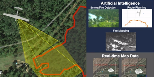
AeroVironment has been working with Nvidia and Microsoft to deliver a prototype AI-enabled system that could help bring advanced wildfire management.

Aerovironment, wildfire, wildland, fire, drone, uas, uav

 In 2018, California experienced its worst wildfire season on record, with uncontrolled fires causing unprecedented death and devastation. 2019 saw another difficult season, with millions of residents experiencing precautionary power shutoffs. With much of the world self-quarantining and the 2020 fire season looming, Nvidia’s virtual GTC 2020 hosted a panel highlighting how AI practitioners are working with forest stewards to bring fire management into a new, data-enabled era.

Firewatch duty was traditionally served by fire lookouts on towers overlooking forests, but moving that role into the 21st century is easier said than done. In order to be truly useful to first responders in a wildfire, an AI model needs to be able to detect smoke – not fire – very, very quickly. After all, by the time a fire is large enough to be easily spotted, it’s typically less containable, and if the smoke is reported too late to act on it, the fire will have had substantial time to grow.  Read More


Monday, April 6, 2020

Request Emergency GIS Help From The ESRI Disaster Response Program for COVID-19


To help public health agencies and other organizations jump-start their response to COVID-19, Esri is providing the ArcGIS Hub Coronavirus Response template at no cost through a complimentary six-month subscription of ArcGIS Online with ArcGIS Hub Basic. ArcGIS Hub is a framework to build your own website to visualize and analyze the COVID-19 crisis in the context of your organization's or community's population and assets.


dis, esri, gps, covid-19, coronavirus, disaster, response,

Thursday, April 2, 2020

CivTAK4.0.1 Has Been Released & Its AWESOME

It will be interesting to see how the civilian version continues to develop and how well it will work in public safety and with drones.

CivTAK 4.0.1 has been released to the Public — “Public Release — Distribution Unlimited” in Government parlance. This is the first time that this enterprise-quality, mobile phone tools that the Government has spent hundreds of millions of dollars on has been available to the public, and it is FREE.
atak, civtak, gis, imagery, geophoto, public safety,

CivTAK has most of the features of its military cousin, ATAK, which is used by hundreds of thousands of military and government users throughout the United States and the world.

Here’s a non-exhaustive list of features:

  • Online or offline maps, including from customizable sources (but no limited license map sources like Bing or Google are supplied), and support for man, many map formats
  • 2-D and 3-D mapping, including import of Pix-3D models from your drone
  • Support for KML, KMZ and other geospatial overlays
  • Elevation heat maps, elevation profiles, 3D views
  • Ability to drop points, draw complex overlays, route following, measurement tools
  • Integrate geo-photos, track recording, playback
  • photo to map feature (Rubber sheeting)
  • Map re-sectioning, to get your position without GPS (Old School mapping)
  • Integrated radio controls supporting numerous radios for first responders (Firefighters, Police, Forest Firefighters, security guards, etc).
  • Customizable toolbars

With radios or a server, such as TAKServer* — or a competitor like TeamConnect or TakLib**, you can also do the following:

  • Team shared situational awareness (where are my friends), including chat, file sharing, pointer sharing,
  • Geo-fences (Keep track of when something goes in/out of a defined area)
  • Data packages (groups of files for complex scenarios)
  • Video display with direct overlay,
  • Emergency notifications
CivTAK is 100% compatible with ATAK, WinTAK, WebTAK, TAKServer and iTAK.

More on CivTAK

Tuesday, February 19, 2019

Water Rescues Thanks To Drone Mapping

“When people fall into water, we need to get them out.” Essex police use the latest technology in their work - including drone mapping.

Pix4D February 17, 2019
Every 90 seconds, a person is reported missing in the UK.

At least once a day, Essex police see a missing person case which requires further investigation. While around 80% of missing persons are found within a day, as many as 5% of cases remain unsolved.

The missing are diverse: they are elderly and children; happily and unhappily married; alone in the world and with a wide support network.

The missing are diverse, but the found often have something in common: water.

Perran Bonner, Drone Manager and Operations Lead in Essex police explains: “Many people are drawn to water. That’s irrespective of their mental health, their age, anything like that - it’s just a natural pull. Quite often people fall in and then get into difficulties - or perhaps they have deliberately fallen in. Either way, we need to go and get them out.”


Essex has one of the longest coastlines in the country. Its green fields are crossed with canals and rivers, and dotted with lakes and ponds.

“In Essex in particular there’s an awful lot of mud here,” continues Bonner. “People are regularly stuck in the mud.”  Read More

Monday, December 3, 2018

Mapping Camp Fire Disaster with Drones

DJI November 2018
DJI works with 16 first response agencies for disaster response and damage assessment for California’s deadliest wild fire

The towns of Paradise and Magalia in Northern California, nestled in the foothills of the Sierra Nevada, were once thriving communities with over 27,000 residents. On November 8th, 2018, the "Camp Fire" changed all of that within hours. Thousands have been affected by this wildfire, close to 100 people lost their lives, many thousands have lost their homes.

Aerial, Drone, Photo, Camp Fire, Disaster, GIS, UAS, UAV, GPS,

Over two days — hovering over the burned-out grounds of the state’s most destructive fire, a legion of drones began recording images of the devastation below in efforts to help the people who lost their homes. By the time they were done, they had collected 70,000 images over 17,000 acres resulting in 1.4 trillion pixels of data.

The detailed footage and maps would help people to determine the condition of their homes — and expedite insurance claims. The footage could also help recovery crews, demolition crews, city planners, scientists and researchers, and the general public, to get a better understanding of the situation. 

The 518 coordinated flights operation, by 16 Northern California emergency responder agencies, is one of the biggest drone response to a disaster scene in the nation’s history. The 16 UAV teams were led by Alameda County Sheriff's Office. Stockton Police, Contra Cost County Sheriff's Office & Menlo Park Fire Protection District had the most team members present, with Union City Police, Hayward Police and Stanislaus County Sheriff's Office providing units as well. San Francisco Police oversaw airspace mitigation. In addition to the mapping flights, over 160 full 360-degrees and interactive panoramas were created with the help of Hangar, as well as geo-referenced video was shot along major roads in Paradise through Survae. This layered data set was processed in record time. 

The photos and videos shot by drones were all georeferenced and stitched into a map format, making it possible for residents to check the status of their homes with the interactive AI app. Authorities in Butte County publicly released the maps and aerial photography even before many residents had been cleared to enter the fire zone to check their homes. Access Butte County's Camp Fire Map.

GIS, GPS, drone, uas, uav, wildland, fire wildfire,

We’re hoping that one, it will help people understand the devastation that we’re dealing with, understand the very difficult task that we have,” said Butte County Sheriff Kory Honea. “We’re hoping it’ll provide them information that will help them get their insurance claims started.”Read more

Friday, December 16, 2016

EMMU Mobile Emergency Response GIS / GPS Mapping Trailer and Geo-Photo

As I was looking back at where EMMU had come from and where EMMU Aerial is today, it was obvious we had come a long way and learned a lot along the way, mostly through our emergency mobile mapping and oblique aerial photography systems.

From the early days of Emergency Mobile Mapping Unit or EMMU in 2000 where we provided a true mobile emergency GIS response capability with our GIS quick response trailer to support wildland firefighters, first responders and search and rescue professionals. 

Read more about the original concept of the EMMU mobile emergency response GIS / GPS mapping system

During an emergency or crisis, maps play a critical role in responding to the event, search and rescue, mitigating further damage, and understanding the extent of the impacts. Geographic Information Systems (GIS) is an appropriate platform to organize the extensive amount of spatial data both generated and utilized during an emergency event. A properly designed and implemented GIS will allow managers and responders to access critical location data in a timely manner so lives and property can be protected and restored.

Mobile, Emergency, Response, GIS, GPS, Mapping, Trailer,

GIS works effectively in all four phases of the disaster management cycle; preparation, mitigation, response and recovery.

 GIS can play a valuable and vital role in;
             Hurricanes
             Tornadoes
             Floods
             Wild Fires
             Earthquakes
             Volcanoes
             Tsunamis
             Landslides
             Search and Rescue
             Epidemics
             Social unrest
             Toxic spills


EMMU GIS Trailers are capable of quickly and efficiently compiling, processing, managing and printing raw data points onto either full-size 36" or 42" color plots, or on easy to distribute 11"x17" pages. The EMMU GIS trailers also have the ability to project maps inside the trailer for emergency managers to quickly survey and understand an ever changing situation. EMMU has top-of-the line hardware, current ESRI GIS software suites, and experienced specialists to provide a GIS solution that will exceed expectations for quality and speed of service.

Mobile, Emergency, Response, GIS, GPS, Mapping, Trailer,

Opportunities for Mobile GIS Systems end with the limits of your imagination. These systems are ideal for emergency management, private, corporate, county and industrial research where onsite mapping technologies and experienced GIS / GPS specialists can save time and cut costs considerably

EMMU GPS Specialists can also assist the incident commander by providing GPS, GIS data integration. GPS is one of the most efficient methods for documenting information regarding the location of facilities, conditions, and environments affected by Wildfire, Floods, Earthquakes, and other incidents.

EMMU GIS units are dispatched out of Central Florida with a fully qualified GIS/GPS Specialist.  Additional GIS /GPS Specialists are available upon request
Standard GIS Unit Features
             8.5 x 24 ft Self contained climate controlled trailer
             Meets OSHA work environment requirements
             Workspace for a minimum of 3 workers
             AC power source (Generator)
             High Speed Satellite Internet Connection
             UPS and line conditioner system
             All workstations, printers and plotters are networked
             1 Xeon 3.0 MHz Desktop
             2 Core 2 Duo Mobile Desktops
             HP 800 PS Large Scale Plotter
             HP 9600 11x17 Printer
             Laser copier, printer, fax, scanner
             Multiple GPS units
             4x4 ATV with GPS  (Optional)

Installed software includes
             ESRI ArcGIS 9.1 and 9.2
             ESRI ArcView 3.3
             Spatial Analyst
             Fire Incident Mapping Tool
             Ventura Tools
             DNR Garmin GPS software
             Adobe Photoshop
             Microsoft Office 

EMMU Inc. also offers Oblique Aerial Photography; we use a professional-grade digital camera with top of the line lenses. The resulting images can be filtered to remove moderate smoke/haze, and enhanced to identify vegetation types. We also utilize Gyro-stabilizing equipment to keep the camera still at the moment the photo is snapped. Thanks to this added stabilization, photographs taken from an airplane or helicopter do not contain the blur seen on many photos. When needed, these cameras can be coupled with a GPS to provide the Latitude and Longitude coordinates in the photo data and on the photo if needed.

Geo, Photo, Oblique, Aerial, Photography, gis, gps,

Years later, EMMU Aerial had developed their skills through extensive operational aerial photography, remote sensing and UAS surveillance work with the military and government agencies. From these beginnings with military systems, we now provide turnkey and flexible training solutions and services for public safety agencies and organizations throughout the U.S.