yubanet.com May 31, 2019
NEVADA CITY, Calif. – Nevada County
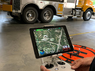
Consolidated Fire District added an Unmanned Aerial Vehicle (UAV) to their
toolbox and after close to a year, the UAV has proved a valuable addition.
Eight district personnel are certified to operate the UAV
and recently we got a demonstration of some of its capabilities at Station 84.
Deputy Fire Marshal Mason explained the versatility of
the UAV and how the agency uses the UAV/UAS (don’t call it a drone) in many
situations.
During a structure fire, the drone can provide a 360-view
of the structure, any adjacent buildings that may be impacted and, most
importantly, the fire behavior. “We can send the UAV up and let it hover over
the incident. It allows us to position our resources more efficiently and have
visual contact with all our firefighters,” Mason said.
Multiple uses
The UAV is not just being used for structure fires, it
can be deployed for any wildland fire and provide valuable reconnaissance.
River rescues, a big part of summer operations, are
time-sensitive and were the major impetus to acquire the UAV. The UAV can cover
a large swath of the Yuba, look for the missing person and pinpoint their
location. While conventional communication in the river canyon can be spotty,
the UAV uses satellite-based navigation and stays within visual range of the
trained operators at all times. The district is scouting locations where the
operators can see a large portion of the river and quickly direct the swift
water rescue team to the patient.
The UAV can hover for 20 minutes on one battery, or fly
16-17 minutes during a river rescue – that’s about 3 miles of river canyon
covered – and can fly at speeds up to 40 mph.
Hazardous materials and suspicious objects can also be
safely inspected from a distance as the video above shows.
One use of the UAV that wasn’t initially obvious is
defensible space inspections (DSI). Mason recounted a request from an
out-of-county property owner for a defensible space inspection of a vacant
parcel. “When we get a call asking for a DSI from a property owner, we can –
with their permission – fly over the
property, send them the pictures and then set up a vegetation management plan.”
Upgrades and mutual aid
With the successful deployment of the UAV, the district
now is looking to expanding the program. A second UAV and additional equipment
for the existing one are on their wish list. The ability to carry a payload,
like a floating device during a river rescue, requires an upgrade. The district
is researching those options and the cost associated with it. Delivering a
flotation device would be done by attaching the device to a lanyard module and
carrying it to a stranded person. A camera with night-vision capabilities is
another upgrade they are considering for search and rescue missions.
Meanwhile more firefighters will go through the
operations training and increase the availability of the tool. “We can deploy
the UAV at the request of another agency, it makes sense to share the resource
and it’s part of the mutual aid we provide each other,” Mason said.


No comments:
Post a Comment