
Monday, June 29, 2020

New DJI Drone Rescue Map Tracks Drone-Assisted Rescues Worldwide

drone, UAS, UAV, SAR, search, rescue, public safety,


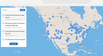
DJI, a leader in civilian drones and aerial imaging technology, today launched an online reference to track events around the world when a drone helped rescue someone from peril. The Drone Rescue Map, available online at https://enterprise.dji.com/drone-rescue-map, shows how more than 400 people around the world have been helped by drones in more than 200 emergencies, and will be continually updated as new rescues occur.

The DJI Drone Rescue Map has been compiled from news stories and social media posts from authoritative sources such as police departments, fire departments and volunteer rescue squads. Each entry on the map includes the location and date of the incident, a brief description, a link to the original story or post, and an easy way to share those incidents online. To make the map as definitive as possible, DJI encourages public safety agencies to share additional drone rescues so they can be included.

“The DJI Drone Rescue Map is now the best global reference for how effective drones are in emergencies, and allows the world to see the tremendous impact drones have had in finding lost people, shortening searches, reducing risks to rescuers and saving lives,” said Romeo Durscher, DJI Senior Director of Public Safety Integration. “Public safety workers already know how drones are revolutionizing their work, and now the rest of the world can see their amazing stories in one place. The DJI Drone Rescue Map honors the incredible rescues they’ve made, and will allow everyone to see how drones help save people in the future.”

The DJI Drone Rescue Map includes instances of drones finding people lost in forests, fields and mountains, often in darkness using thermal imaging cameras; dropping life preservers to people struggling in water; locating boaters stranded on remote waterways; and helping rescue people who were at risk of harming themselves. The map does not include incidents when a drone is simply used as part of a larger search process; instead, a drone must have directly located, assisted and/or rescued a person in peril.

Many of these incidents illustrate how drones can find missing people more quickly than a traditional ground-based search, allowing victims to be brought to safety faster, more easily, and with less risk and burden for their rescuers. In some of the incidents on the DJI Drone Rescue Map, the drone helped accelerate a rescue and allow first responders to operate more efficiently. In other incidents, the drone clearly made the difference between life and death.

“I know how important drones are for people in distress, because a drone saved my life,” said Jason Mabee, a Maryland man who was injured and near death last year in a local park when he was found by a volunteer drone pilot. “My family and I are eternally grateful that a total stranger was able to use his drone to find me. It’s comforting to know that drones are helping so many other people around the world too, and I hope the DJI Drone Rescue Map demonstrates just why drones are so important in emergencies.”

“Drones have changed the game for finding and saving people lost in difficult conditions, and twice last year drones made the difference for us in finding and saving stranded hikers in dangerous terrain at night,” said Kyle Nordfors, Drone Team Coordinator for Weber County Search and Rescue in Utah. “Drones helped make these rescues possible while reducing risk and strain on our volunteer rescue force. We’re excited to see our successful efforts represented on the DJI Drone Rescue Map, and we hope it shows people all over the world how important drones are for saving lives and protecting the rescuers.”

PC Tom Shainberg, Senior Drone Pilot of the Alliance Drone Team for the Devon & Cornwall and Dorset police forces in England, said: “The Alliance Drone Team is proud to be a leader in adapting drone technology for police incidents, and we’re glad to see our successful drone rescues – such as finding a vulnerable man huddled near the edge of a cliff – being shared wider, along with similar accomplishments from other public safety agencies from around the world via the Drone Rescue Map.”

The map includes rescues recorded in 27 countries across five continents, and shows how drone technology has moved from an experimental concept to standard public safety equipment. The first drone rescue was recorded in Canada in 2013, the next one was more than a year later, and early examples of drone rescues were as likely to be performed by helpful bystanders as by professionals. Today, drone rescues are reported about once a week on average, and public safety agencies routinely share those success stories on social media.

“Hundreds of examples now make clear that making drones widely accessible, with low barriers to entry and subject to a progressive set of operational regulations, leads inevitably to saving more lives around the world,” said Brendan Schulman, DJI Vice President of Policy & Legal Affairs. “The DJI Drone Rescue Map is a powerful resource for policymakers to understand the impact drones have on protecting vulnerable people in their own communities, and the detrimental consequences of policies that would restrict or discourage the use of drones, or increase the cost of using them. Regions with less favorable operating rules for drones appear to have substantially fewer reports of drone rescues.”

DJI has previously released two detailed reports on how drones have been used to rescue people from peril around the world. The first, in 2017, counted 59 people rescued by drones, and the second saw the global total rise to 124 by 2018. DJI monitors global news coverage, drone-related social media, and other sources to find new examples of drone rescues, but understands that many similar incidents may not yet be recorded on the map. Anyone who knows of a drone-involved rescue not included on the DJI Drone Rescue Map can submit it through a form at the bottom of the map page. These submissions will be reviewed for publication on the map, so DJI asks anyone submitting information about a rescue to respect the privacy rights and expectations of the persons involved, and to not share any confidential or sensitive information about agency operations.

Wednesday, June 24, 2020

Canoers rescued from Bridgewater’s Town River with the help of a drone


The Enterprise June 22, 2020
BRIDGEWATER — Two men whose canoe was damaged on the Town River were rescued with the help of drone thermal imaging.

drone, uas, uav, search, rescue, sar, river, swiftwater, water

“Deploying the drone from the deck of the fire boat and using thermal imaging gave responders the visibility they needed to locate the individuals,” Bridgewater Police Chief Christopher Delmonte said in a statement.

The father of one of the men called West Bridgewater police around 8:30 p.m. Saturday and reported that the canoe his son and friend were in was damaged and taking on water.

Bridgewater police and fire units went to the Lake Nippenicket boat ramp to launch their rescue boat. An officer and firefighters went to the northern part of the lake to enter the Town River.

First responders were able to talk to the canoers, but were not immediately able to identify their exact location, according to police. Officer Chris Rondeau launched a drone from the boat to search the area with thermal imaging.

From footage of the rescue, the 22-year-old men were seen waving at the drone when it found their location, which was about 200 feet away from the boat.

The men were rescued from the chest deep part of the river and brought back to shore, where they were evaluated and reunited with families.

Delmonte said the weather conditions were favorable for the rescue and the canoers were not injured.

“This rescue effort is a great example of the Bridgewater police and fire departments working together,” Fire Chief Thomas Levy said in a statement. “I commend the quick action of the individuals involved with this water rescue.”

Tuesday, June 9, 2020

Drone Leads Rescuers to Overdue Backpackers in Aspen

The Aspen June 5, 2020
Two overdue backpackers were located Wednesday with the help of a search and rescue drone after deep snow unexpectedly delayed the pair’s 27-mile long journey through the Maroon Bells Wilderness Area.


According to Mountain Rescue Aspen, the two males in their 20s set out for a three-backpacking trip on Sunday. The backpackers intended to hike the Fravert Basin, also known as the Four Pass Loop. When the pair did not return on Tuesday as expected one of their family members reported them overdue. 

A massive search was launched for the overdue backpackers, including the use of a drone, helicopter, fixed-wing aircraft, and  10 search and rescue personnel.

A drone flying at about 500 feet in altitude spotted the overdue backpackers at about 5:20 p.m. near Crater Lake. They were found tired, but uninjured.  Despite the snowy conditions slowing down their progress, rescuers say both backpackers were “well equipped” to spend an extra night in the wilderness.

Saturday, June 6, 2020

Cops Releases New Report On The Use Of Drones In Policing


A Report on the Use of Drones by Public Safety Agencies—and a Wake-Up Call about the Threat of Malicious Drone Attacks

The Community Oriented Policing Services (COPS) division of the Department of Justice recently released their report on the use of drones in policing. There’s a lot of good information here for police departments, broken into 3 sections: Pre-Implementation Considerations; Establishing a Drone Program; and Malicious Use of Drones. In particular the report is geared toward helping departments maintain transparency and communication with the community about the use of drones. Read More.


Monday, May 25, 2020

Utah Climber Rescued From Remote Cliff With Assistance of Drone and Helicopter

drone, rescue, search, uas, uav, sar,
The search and rescue team launched a drone to identify the man’s location and relayed to DPS helicopter crews to hoist him from the cliff. (Uintah County Sheriff’s Office)
Fox News May 25, 2020
A Utah climber who fell and cracked his head while scaling a cliff by himself on Sunday was rescued after he regained consciousness, and nearby campers heard his cries for help, authorities said.

The 52-year-old man, whose name has not been released, was climbing up a slot in the cliff near Jones Hole National Fish Hatchery, by the Colorado border, when he fell an unknown distance, the Uintah County Sheriff’s Office said. He told rescuers he didn’t know how long he was unconscious before he awoke and yelled for help.

The group of campers, which included a member of the sheriff’s search and rescue team, heard the stranded man’s calls. They were unable to pinpoint the man’s location because his cries echoed off the cliff walls. They called authorities around 1:40 p.m., setting off a five-hour rescue operation.

"The area he was climbing in is out of the way. You wouldn't really expect someone to be climbing there," Sheriff's Sgt. Dustin Cheshire said. "If it hadn't been for the camping group with a Wasatch County search and rescue member who heard this guy yelling and screaming, it's unlikely anyone would have found him."

The sheriff’s office sent a search and rescue team and requested helicopter crews from both the Utah Department of Public Safety (DPS) and Classic Air Medical.

The Classic Air Medical crew spotted the man after arriving, but the steep terrain prevented them from reaching him, the sheriff’s office said.

The search and rescue team launched a drone to identify the man’s location and told the DPS helicopter crew. The DPS crew was able to reach the man and hoist him from the cliff.

Saturday, May 23, 2020

Drone and Ropes Help Rescue Drivers Trapped in River

Well done firefighters, It’s good to see positive use of drone.


May 18, 2020
Firefighters use a drone and ropes to rescue drivers trapped in river due to sudden water rise in Zhangjiajie, China.

Thursday, May 14, 2020

Loc8 Software Helping Find Missing Persons with a Drone / UAS – Another Tool in the Toolbox

As a follow on to our blog post Drones for Search and Rescue (SAR) – Another Tool in The Toolbox,  where we discussed how incredibly useful drones are.  A search and rescue drone used by emergency services, such as police, firefighters or volunteer rescue teams, is ideal for searching over vast areas for missing persons and crime victims in need of rescue and in any environment.  Search times can be significantly reduced while limiting potential risk to the party being rescued as well as rescuers.

In 2018 DJI reported that 133 people around the world were rescued after being found with drones.  Also, of note is that 2018 marked a new milestone in public safety drone use, as four people were rescued by drones in three separate incidents on two continents on a single day.  

These numbers are undoubtedly higher as more search and rescue organizations discover the benefits of drones.  While many search and rescue drones are outfitted with infrared or thermal and high-resolution cameras to help assist in finding missing people.  This is not always the case.  Many of times, Searcher use their drones with their regular cameras to take aerial photos of a large area where people are reported missing or lost.

This is where the challenge begins, how do you search, sift or squint through often hundreds and hundreds of aerial photos looking for the missing individual(s)?

According to Gene Robinson. “The squinting process is where searchers comb through photos one at a time for any details that might point to recently disturbed earth or a walking trail, and for the colors of the clothes the missing person was last seen wearing. Different colors and textures represent potential clues that could lead to a recovery. A speck of blue on the screen points to a color that is rarely found in nature, and in Texas, when people go missing near ranch land, blue is often the color of the jeans they're last seen wearing.”   A SAR study shows humans are only capable of spotting a target 30% of the time when reviewing digital images.

Loc8, search, rescue, sofware, missing person, target, public safety,

Loc8’s software image scanning process can dramatically increase your success rate in finding your target!  Loc8 is a software solution that empowers search and rescue agencies and emergency responders to quickly scan images from aerial drone footage to locate missing people or objects by using image scanning technology that isolates specific pixel clusters.  Loc8 can go through thousands of images, much faster than is humanly possible, to locate specific color values that might represent blue in the missing persons jeans.  Once Loc8 identifies a target in an individual image it will circle it in red for quick and easy identification by the searcher.

The final product includes a map with an aerial view and a quality report that is produced with mission specific data with Latitude and Longitude coordinates of the image.  This can be passed on to searchers in the field to locate the target.

Loc8’s software is a very exciting advancement in search and rescue that I have now utilized on training and actual searches and may help your SAR team find missing persons faster.  Loc8’s software should be - another tool in the toolbox!