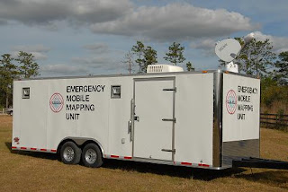
From the early days of Emergency Mobile Mapping Unit or EMMU in 2000 where we
provided a true mobile
emergency GIS response capability with our GIS quick response trailer to
support wildland firefighters, first responders and search and rescue
professionals.
Read more about the original concept of the EMMU mobile emergency response GIS / GPS mapping system
Read more about the original concept of the EMMU mobile emergency response GIS / GPS mapping system
During an emergency or crisis, maps play a critical role
in responding to the event, search and rescue, mitigating further damage, and
understanding the extent of the impacts. Geographic Information Systems (GIS)
is an appropriate platform to organize the extensive amount of spatial data
both generated and utilized during an emergency event. A properly designed and
implemented GIS will allow managers and responders to access critical location
data in a timely manner so lives and property can be protected and restored.
GIS works effectively in all four phases of the disaster
management cycle; preparation, mitigation, response and recovery.
GIS can play a
valuable and vital role in;
• Hurricanes
• Tornadoes
• Floods
• Wild
Fires
• Earthquakes
• Volcanoes
• Tsunamis
• Landslides
• Search
and Rescue
• Epidemics
• Social
unrest
• Toxic
spills
EMMU GIS Trailers are capable of quickly and efficiently
compiling, processing, managing and printing raw data points onto either
full-size 36" or 42" color plots, or on easy to distribute
11"x17" pages. The EMMU GIS trailers also have the ability to project
maps inside the trailer for emergency managers to quickly survey and understand
an ever changing situation. EMMU has top-of-the line hardware, current ESRI GIS
software suites, and experienced specialists to provide a GIS solution that
will exceed expectations for quality and speed of service.
Opportunities for Mobile GIS Systems end with the limits
of your imagination. These systems are ideal for emergency management, private,
corporate, county and industrial research where onsite mapping technologies and
experienced GIS / GPS specialists can save time and cut costs considerably
EMMU GPS Specialists can also assist the incident
commander by providing GPS, GIS data integration. GPS is one of the most
efficient methods for documenting information regarding the location of
facilities, conditions, and environments affected by Wildfire, Floods,
Earthquakes, and other incidents.
EMMU GIS units are dispatched out of Central Florida with
a fully qualified GIS/GPS Specialist.
Additional GIS /GPS Specialists are available upon request
Standard GIS Unit Features
• 8.5 x
24 ft Self contained climate controlled trailer
• Meets
OSHA work environment requirements
• Workspace
for a minimum of 3 workers
• AC
power source (Generator)
• High
Speed Satellite Internet Connection
• UPS
and line conditioner system
• All
workstations, printers and plotters are networked
• 1 Xeon
3.0 MHz Desktop
• 2 Core
2 Duo Mobile Desktops
• HP 800
PS Large Scale Plotter
• HP
9600 11x17 Printer
• Laser
copier, printer, fax, scanner
• Multiple
GPS units
• 4x4
ATV with GPS (Optional)
Installed software includes
• ESRI ArcGIS
9.1 and 9.2
• ESRI ArcView
3.3
• Spatial
Analyst
• Fire
Incident Mapping Tool
• Ventura
Tools
• DNR
Garmin GPS software
• Adobe
Photoshop
• Microsoft
Office
EMMU Inc. also offers Oblique Aerial Photography; we use
a professional-grade digital camera with top of the line lenses. The resulting
images can be filtered to remove moderate smoke/haze, and enhanced to identify
vegetation types. We also utilize Gyro-stabilizing equipment to keep the camera
still at the moment the photo is snapped. Thanks to this added stabilization,
photographs taken from an airplane or helicopter do not contain the blur seen
on many photos. When needed, these cameras can be coupled with a GPS to provide
the Latitude and Longitude coordinates in the photo data and on the photo if
needed.
Years later, EMMU Aerial had developed their skills through extensive operational aerial photography, remote sensing and UAS surveillance work with the military and government agencies. From these beginnings with military systems, we now provide turnkey and flexible training solutions and services for public safety agencies and organizations throughout the U.S.


